Eastern Hajar GPX Downloads and Maps – Oman Hiking Routes
These zipped GPX files contain thirty-eight tracks in the Eastern Hajar and are available for free. Download to a computer and transfer them to a GPS device such as a Garmin. Free applications such as Garmin BaseCamp can be used to combine or split track segments to create complete routes. The tracks involve scrambling but no exposure. Some are long—up to 31 km—but are feasible as day walks because the As Salmah plateau is relatively easy terrain. Elevations range from sea level to 1930 m. These routes are intended for hikers competent in GPS navigation, as they are neither marked nor clearly visible on the ground. The tracks are based on my records from 2003 to 2009, together with more recent data from an Omani companion. Their quality is not as high as the Western Hajar data, which was resurveyed between 2018 and 2020 using a newer Garmin device.
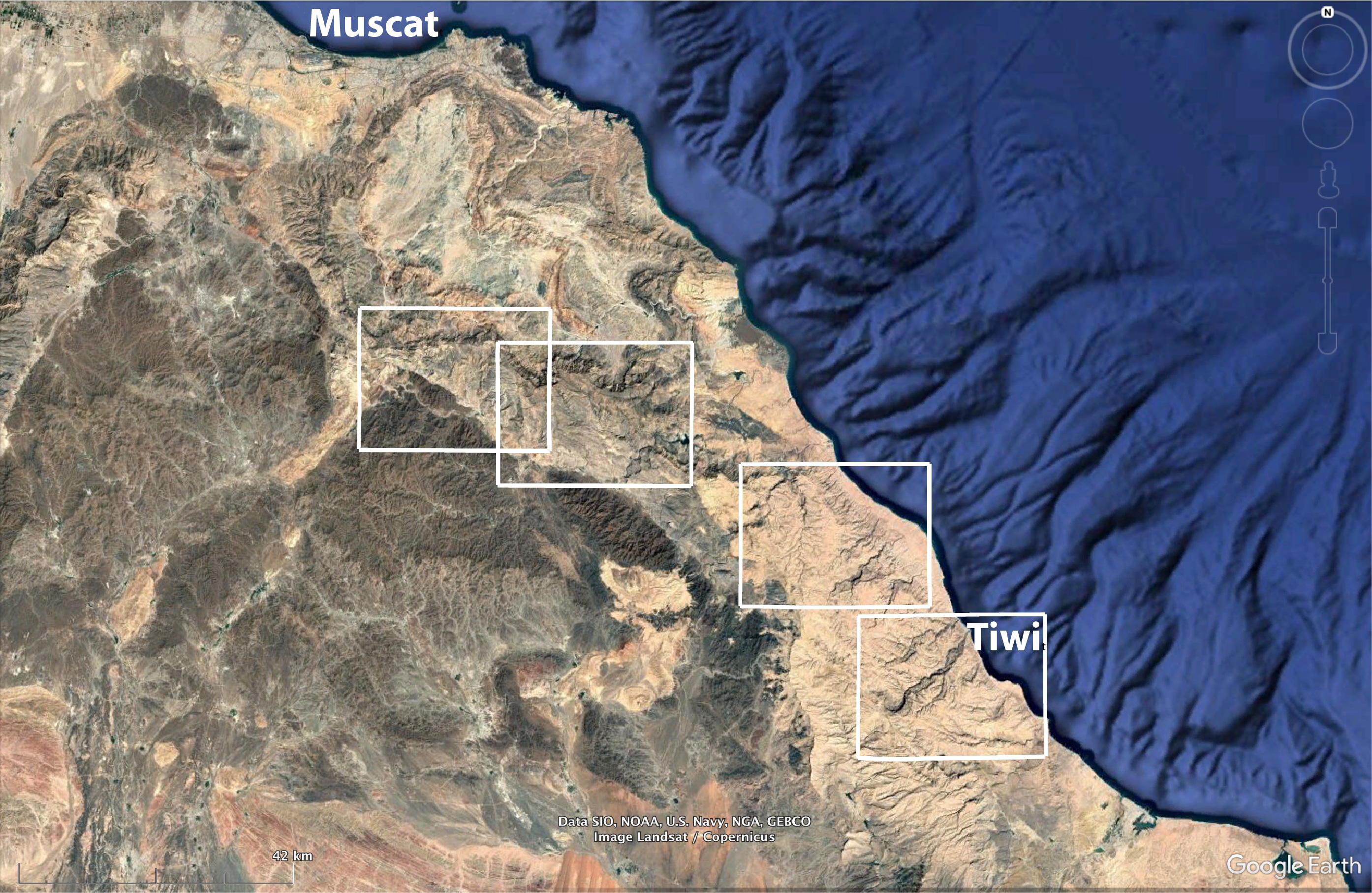
Four purpose-made contour maps of the Eastern Hajar will be available for purchase in winter 2026/2027. Each map will be A2 size 1:50,000 scale, printed together on a double-sided A1 folded sheet and sold on this website using the distributor Cordee. The borders of these four maps are shown in the Google Earth image. Draft versions of these four maps are available now on this webpage for download in PDF.
There is no reliable standing water in the Eastern Hajar. There are no springs on the higher elevations, but there are several flowing wadis with villages next to their irrigated date plantations on both the west and east foothills of the mountain range, and a few mountain settlements of shawawiya pastoralists who have water tanks. The villages that have flowing falaj are marked on the maps. Every effort has been made in the guidebook Wilderness Trekking Oman and on this website to inform you of the precautions necessary for walking in this remote and sparsely populated mountain range. Mountain travel involves unavoidable natural hazards. The author accepts no responsibility for any dangerous situations encountered.
GPX tracks are grouped into four areas corresponding to the maps
Wadi As Sirrin — Map 1
The north facing cliff that dominates this map is part of a protected park called the Wadi As Sirrin Reserve where entry requires written permission from the Environmental Authority in Muscat. I am trying to determine the best way to obtain this permit, and will update this page when instructions are available. The ledges on this cliff are browsed by a rare native goat called the Arabian tahr. This map has a 4WD road and a walking track, both running north/south.
⬇ Eastern Hajar GPX routes – Map 1 (Wadi As Sirrin) and Eastern Hajar hiking map 1, Oman – Wadi As Sirrin (PDF)- Qbroot to Alka, 4WD track, 30 km, ascending 867 m, descending 631 m
- Highway 25 to Wadi As Sirrin, 25 km, ascending 1444 m, descending 1407 m
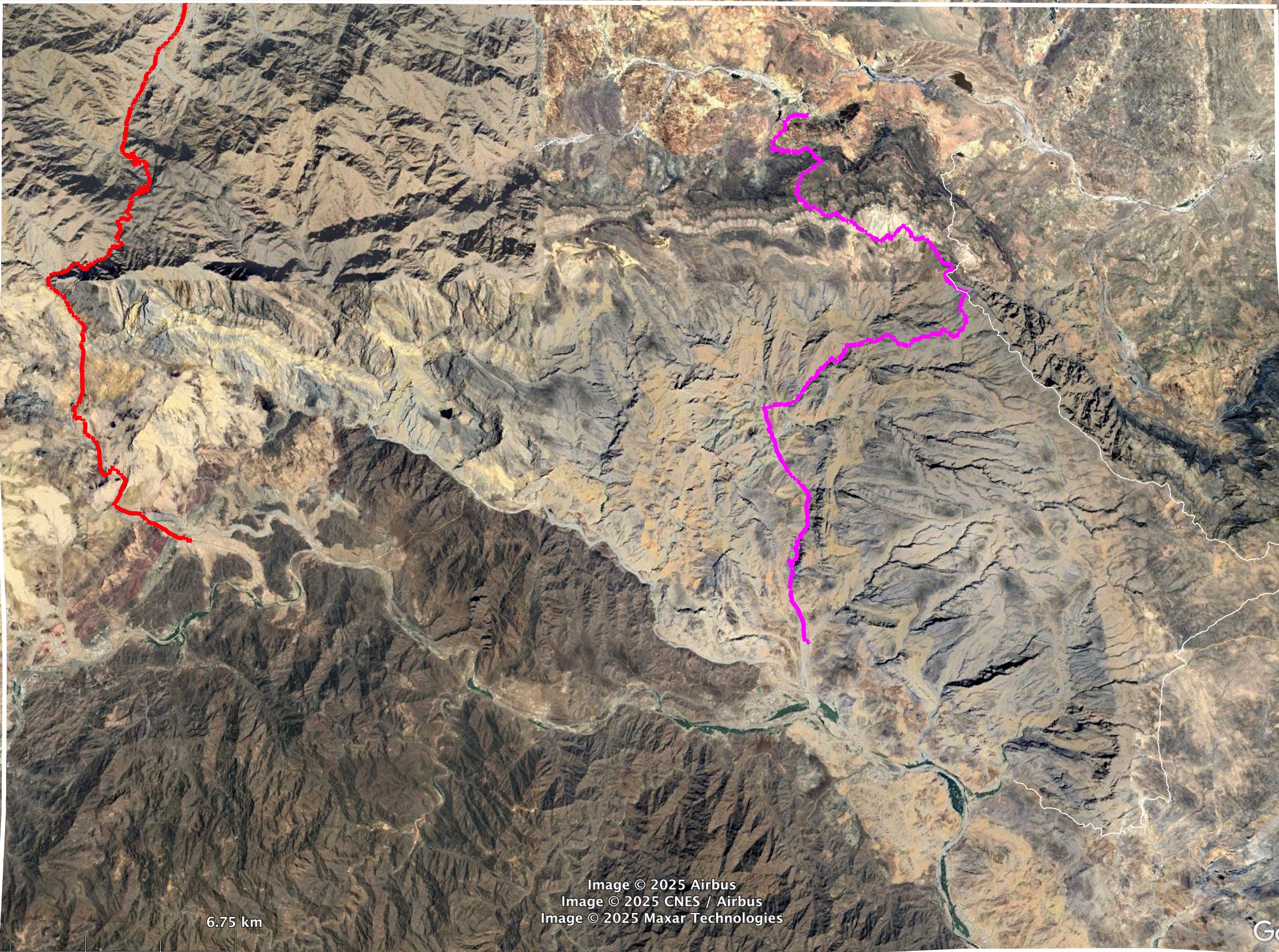
Siya, Al Mudabghah, Al Misfah — Map 2
The village of Siya in the top centre of this map is 45 minutes’ drive from Muscat. Directly to the south of Siya is a north facing cliff that has to be climbed 1400 m to reach the beginning of four tracks. This donkey track ascent starts from a small settlement of government housing at the end of a 2km gravel road leading up from Siya. Two of the four tracks that start at the top of the cliff cross the mountain range exiting onto Highway 25. The other two tracks follow the cliff line west and east, finishing on the coastal side of the mountains. The track to the west enters the Wadi As Sireen Reserve, so permission is required. The ascent from Siya followed by walking any one of these four tracks will take two days. Winter camping at the top of the cliff above Siya, elevation 1960 m, needs cold weather gear. It can freeze overnight.
⬇ Eastern Hajar GPX routes – Map 2 (Siya, Al Mudabghah, Al Misfah) and Eastern Hajar hiking map 2, Oman – Siya, Al Mudabghah, Al Misfah (PDF)- 1 Ascent from Siya to clifftop, 6km, ascending 1400 m
- 2 Clifftop to Kawb, 25 km, ascending 524 m, descending 1977 m
- 3 Clifftop to Al Mudabghah, 19 km, descending 1500 m
- 4 Clifftop to Highway 25, 31 km, ascending 350 m, descending 1950 m. The lower 15 km is a 4WD road
- 5 Clifftop to Al Misfah, 26 km, ascending 665 m, descending 2370 m
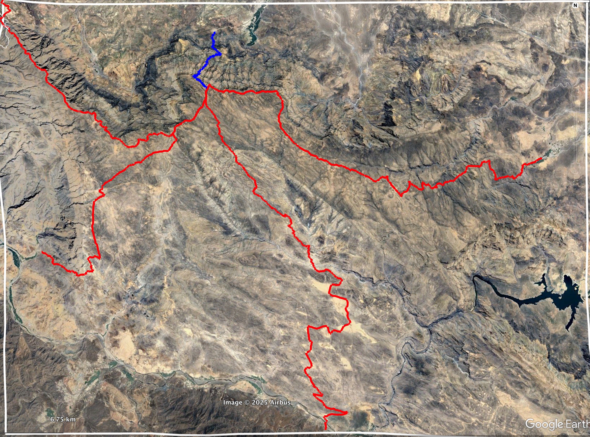
As Siwayh, Sawqah and Amq Ar Rabakh — Map 3
The tracks on this map are between the villages of As Siwayh, Sawqah, Amq Ar Rabakh, Qalaat, Wisal and tracks on both sides of Wadi Taab. There are also five tracks from the coastal highway 17 starting near sea level, so best walked during the coldest months. As Siwayh is at the roadhead on Wadi Al Arbiyyin, while the road to Sawqah is from the interior side of the mountains. Loop walks will avoid a long drive back to Muscat and the logistics of having vehicle transport on both sides of the mountain. The wadi villages have water so multi-day walks between them are possible, for example from Amq Ar Rabakh road to Sawqah then As Siwayh and return along the cliff edge. The tracks on this map pass flowing wadis, massive caves and Bronze Age tombs.
⬇ Eastern Hajar GPX routes – Map 3 (As Siwayh, Sawqah and Amq Ar Rabakh) and Eastern Hajar hiking map 3, Oman – As Siwayh, Sawqah and Amq Ar Rabakh (PDF)- 01 Highway 17 to B junction, cave, 6 km, ascending 420 m
- 02 Highway 17 to A junction, pass, 9 km, ascending 765 m, descending 252 m
- 03 Highway 17 to cave then loop return, 16 km, ascending and descending 1080 m
- 04 Highway 17 to Majlis Al Jin Cave, 18 km, ascending 1420 m. This is the original track to this cave before the road existed
- 15 Qalaat to Sawqah, 8 km, ascending 600 m, descending 780 m
- 16 Sawqah to roadside heading south to desert, 5 km, ascending 750 m, descending 350 m
- 17 Sawqah to Qalaat, 12 km, ascending 900 m, descending 900 m
- 18 Near As Siwayh to C junction, donkey track avoiding canyon swim, 8 km, ascending 800 m, descending 400 m
- 05 G to H junctions, south bank of Wadi Fins, 9 km
- 06 Amq Ar Rabakh road to Tahery Cave, 4 km, descending 170 m
- 07 Amq Ar Rabakh road houses F junction, 11 km, ascending and descending 500 m
- 08 Amq Ar Rabakh road to Wadi Ta'ab terraces, 1.3 km
- 09 Amq Ar Rabakh road to Majlis Al Jin Cave, man-track, 5 km
- 10 Amq Ar Rabakh road to Majlis Al Jin Cave, donkey track, 8 km
- 11 Amq Ar Rabakh road to Wisal loop return, 24 km, ascending 1140 m, descending 900 m
- 12 E junction to Wadi Al Arbiyyin, 21 km
- 13 Amq roadside 3 to cliff ascent, 17 km
- 14 Tahery Cave to Al Jamhah, 5 km, ascending 285 m, descending 110 m
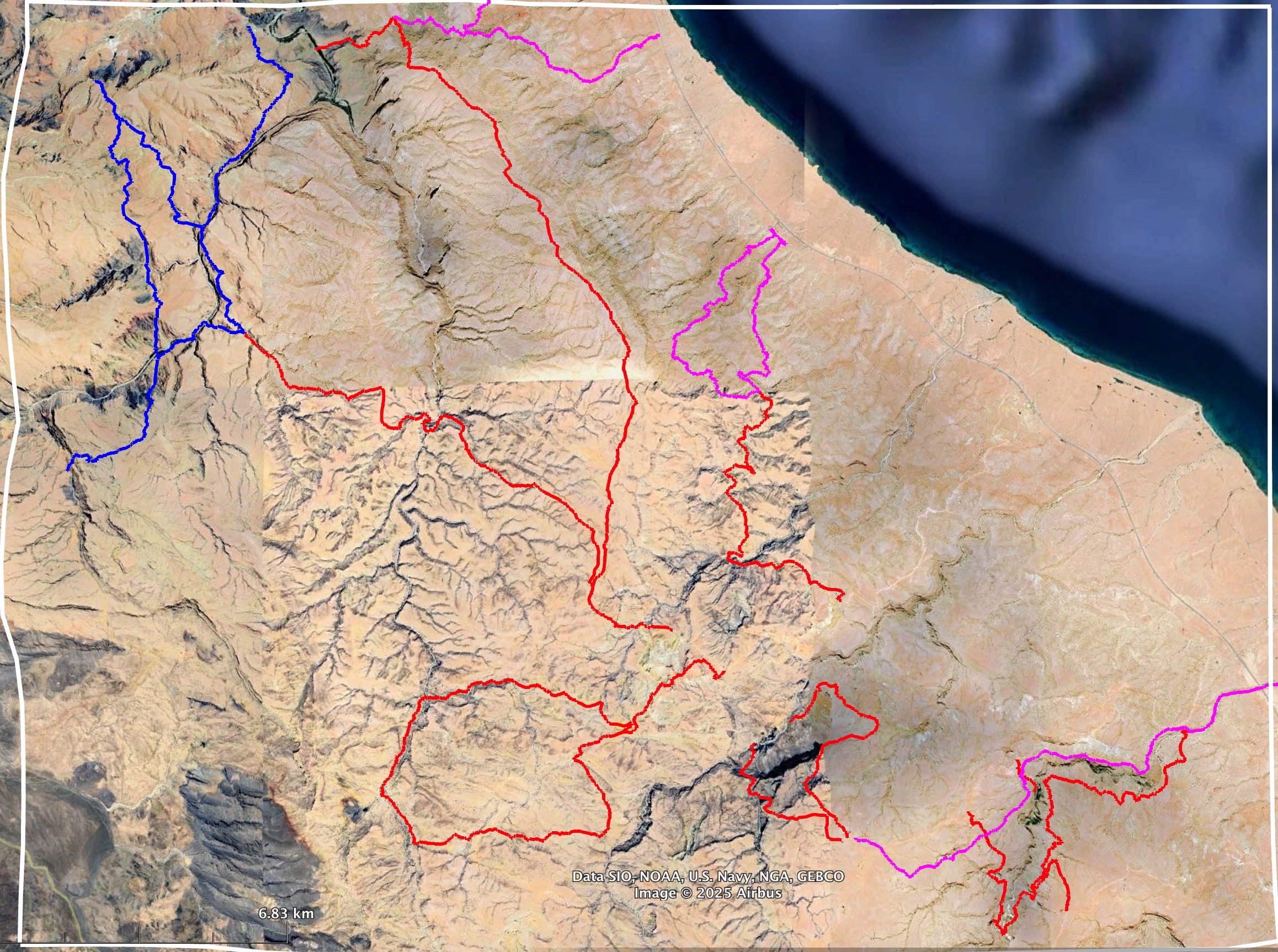
Wadi Ash Shab to Tiwi and Qalhat — Map 4
The tracks on this map connect the coast with mountain villages. They follow Wadi Ash Shab, cross between Wadi Tiwi and Wadi Ash Shab, and follow the wadis running into Qalhat. Some of these villages have springs and long established terraced gardens, others are recent settlements built by the government for the shawawiya semi-nomadic pastoralists. All these villages now have 4WD gravel road connections leading either to the coast or the interior on the west side of the mountains. The driving time on these rough roads is long, so it is fine to obtain drinking water from these villages but not rely on them for vehicular transport.
⬇ Eastern Hajar GPX routes – Map 4 (Wadi Shab to Tiwi and Qalhat) and Eastern Hajar hiking map 4, Oman – Wadi Shab to Tiwi and Qalhat (PDF)- 01 J2 track junction in Wadi Ash Shab to Jamha, 13 km, ascending 1370m
- 02 Harat Ash Shab to Al Jaylah, 22 km, ascending 1610 m, descending 320 m
- 03 Qataah to J3 track junction, 11 km, ascending 940 m, descending 220 m
- 04 Al Jihal to J6 track junction, 4 km, ascending 470 m
- 05 J6 to J7 track junctions South of Wadi Ash Shab, 3 km, ascending 100 m, descending 140 m
- 06 Al Jihal to near Al Ghumb, 2 km, ascending 320 m
- 07 J1 track junction to near Al Ghumb, 9 km, ascending 580 m, descending 550 m
- 12 Highway 17 Qalhat towards Kabda, 9 km, ascending 560 m
- 13 Kabda to Haloot, 23 km, ascending 1800 m, descending 420 m

- 08 J4 to J5 track junction, 4 km, ascending 230 m, descending 80 m
- 09 Al Ghumb to J5 junction, 8 km, ascending 630 m, descending 520 m
- 10 J5 junction to Thiqab, 15 km, ascending 1130 m, descending 300 m
- 11 Tiwi road climb to J5 junction, 2.5 km, ascending 310 m
Waypoints for all four Eastern Hajar maps
⬇ Eastern Hajar GPX waypoints (all hiking routes)Please send any feedback you wish to share with other hikers to me at john@hajarhiking.com and I will post to the feedback tab on this website.
