Wilderness Trekking Oman, 209 km Western Hajar Traverse

Wilderness Trekking Oman, 209 km Western Hajar Traverse

This website is a practical guide to hiking in the Hajar Mountains of Oman, including the 209 km Western Hajar Traverse, a sixteen-day route following the spine of the range. The name of the website, hajarhiking, comes from Hajar, which is both the name of the mountains and the Arabic word for rock. It includes everything needed for the self-guided, self-provisioned traverse, as well as one- or two-day walks in Wadi An Nakhur, the Eastern Hajar, and Jabal Al Kawr. The best walking weather in Oman is from mid-November to March.

The Western Hajar Traverse is divided into eight one-day walks, two two-day walks and one four-day walk. Road access between the eleven stages makes it practical to walk them individually rather than complete the full traverse. The route climbs to the highest accessible peak in Oman (2999 m), as the higher summit lies within a military restricted area. It then finishes in remote dry valleys, known as wadis, where steep cliffs have prevented road construction and the extension of electricity networks. This isolation has preserved an Arabian mountain lifestyle that has existed for centuries.

Exploring the Hajar Mountains with my family and Omani companions was my passion during the sixteen years I lived in Oman. My aim is to revive the historic donkey caravan routes and man-tracks that link the mountain villages, encouraging walking tourism that can support an emerging village hospitality industry based on restored traditional houses. Without the custom of visiting walkers, many of these remote settlements may fall into ruin.

The potential impact of long-distance walking routes is well illustrated by the 630-mile South West Coast Path in the UK. It contributes around 5% of tourism spending across Cornwall, Devon, Dorset and Somerset. Of this total, 76% is generated by overnight walkers. South West Coast Path Economic Impact Study (2012)

Route Difficulty

This traverse is intended for hikers who are competent with GPS navigation, as only six of the eleven stages are waymarked. In Oman there are no mountain rangers, so hikers on this route must be fully self-reliant. Shorter route options are available. One includes two chain ladders that do not require ropes which reduces the traverse by a day. There are two multi-day circuits: one with serviced accommodation and the other entirely in wilderness. A loop within the route can also be used to create a three-day wilderness circuit, or it can be skipped altogether to reduce the full traverse by another three days.

Feedback

One walking party wrote: “Given all our previous field experience, including mountains of the Pamir, Tian-Shan and Caucasus, the route still seemed difficult and sometimes dangerous to us, but really spectacular.” Other walkers have compared its difficulty to the hardest sections of the GR20 in Corsica, the Jordan Trail, the Great Himalayan Trail and the Transcaucasian Trail. You can read this and other feedback received since publication in 2020, and you are encouraged to send your own comments to my email.

Contents

This website describes where to go, what to carry, where to sleep, and most importantly where to find drinking water. The same practical information appears in the first three chapters of the guidebook Wilderness Trekking Oman. The entire guidebook and maps are available as a free guidebook and map download in PDF or iBook format. The paperback edition is available from Amazon or Nomad Publishing, and the two-sided A1 folded map from Cordee map distributors.

The guidebook and this website describe and illustrate the sights encountered on the traverse, including geology, the falaj irrigation system, and traditional Omani crafts. To make the most of time spent meeting Omanis on the tracks, walkers will find it helpful to learn about their history, and the lifestyles of the semi-nomadic pastoralists and their hosts, who own and manage the guest houses in the settled farming villages. For the benefit of interactions with all Omanis, it is prudent to appreciate the mountain etiquette and for the curious there are videos of three presentations on the Western Hajar Traverse and cartography in Oman by the author.

GPX files for the 209 km Western Hajar Traverse, together with 400 km of side routes, 170 km of ultra-marathon trail, and 266 waypoints, can be downloaded from the Western Hajar GPX downloads (Oman hiking routes). The waypoints include villages, guest houses, hotels, and local names of semi-nomadic pastoral campsites with their plastic water tanks, as well as caves, mountain passes, historic track junctions and remote water sources. These water sources include mountain springs, water-dripping cliffs, cave pools, man-made reservoirs, isolated falaj-irrigated gardens and wadi dams. Historical features located near the traverse are also included, such as Bronze Age tombs and pre-Islamic rock art.

Some hikers may choose to arrange vehicle support, with friends meeting them in a 4WD vehicle at the road intersections marking the ends of the eleven stages. For their benefit the guidebook includes optional excursions starting from eight of these rendezvous points. Other resupply options are possible by mailing supplies in advance to the guest houses and hotels passed on the traverse, which can serve as collection points.

Disclaimer

Every effort has been made in this website and in the guidebook Wilderness Trekking Oman to provide guidance on navigation, what to carry and where to find drinking water each night. The author accepts no responsibility for any dangerous circumstances encountered while using this information. Hiking the route is undertaken entirely at the user’s own risk.

Western Hajar Traverse Details

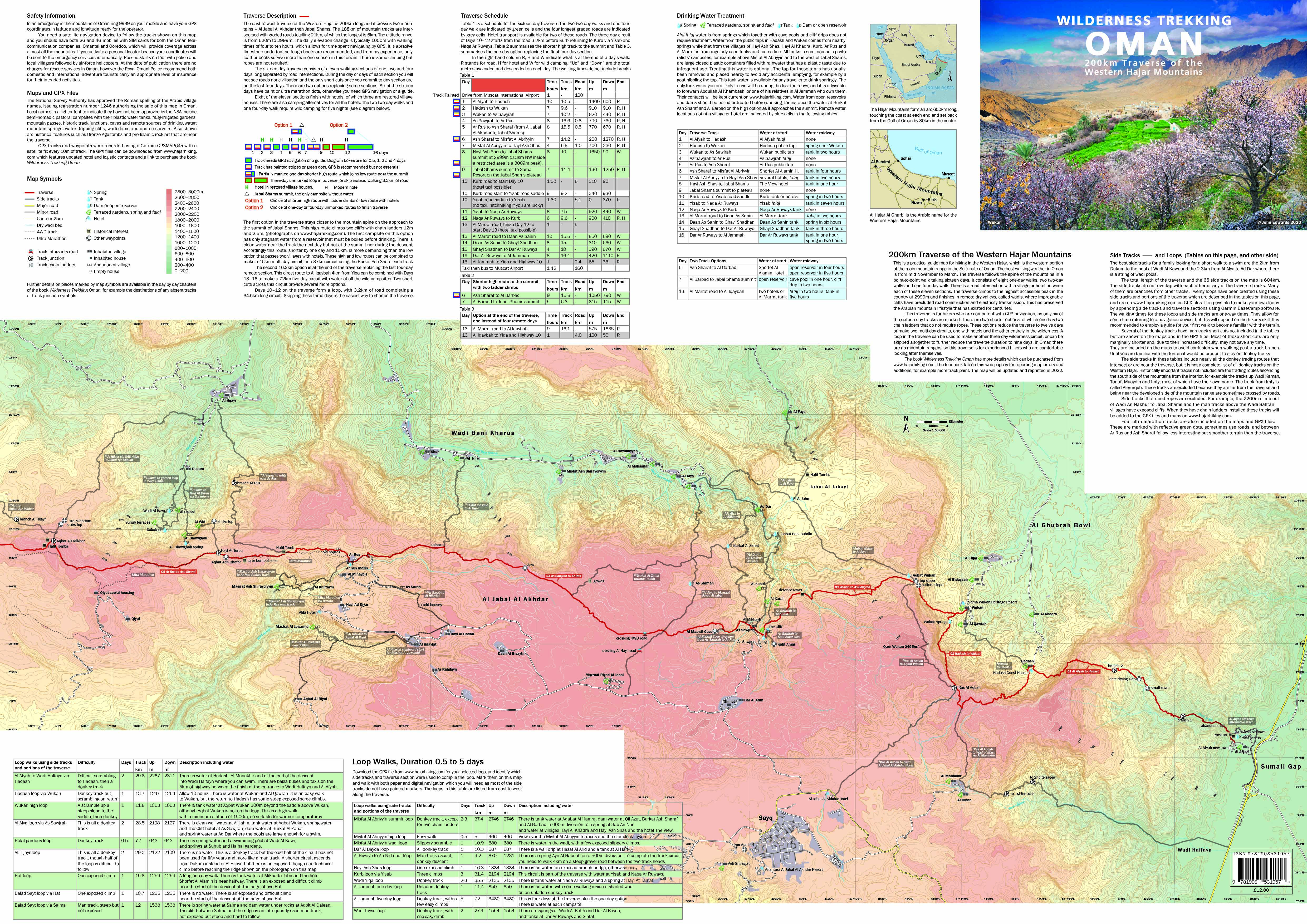
The Western Hajar Traverse runs east to west for 209 km and crosses the two main massifs—Al Jabal Al Akhdar and Jabal Shams. Of the total distance, 188 km are mountain tracks interspersed with 21 km of graded roads, the longest of which is 6 km. The altitude range is 620–2999 m. Daily elevation change is typically about 1000 m, with four to ten hours of walking allowing for time spent navigating by GPS. There is some climbing, but ropes are not required.

The sixteen-day traverse consists of eleven walking stages of one, two and four days, separated by road intersections. During each stage there are no roads nor settlements. Once committed to a stage, the only shortcuts occur on the final four days. Two alternative options allow some stages of the traverse to be replaced. Six of the sixteen days are waymarked; otherwise GPS navigation or a guide is required. There are sixteen side routes branching north from the traverse and five to the south that can be used to create alternative multi-day routes.

Eight of the first nine days end at either guest houses or hotels, with only the summit stage requiring wild camping in the first half of the traverse. There is also a six-day walk via the low route that can be done entirely using serviced accommodation. This runs from Al Afyah to Misfat Al Abriyyin, bypassing the summit. Four of these nights will be spent in delightfully restored village houses, but one of the two hotels on this route—at Ar Rus—is the very expensive Alila. Wild camping is also possible every night. In contrast, the second half of the traverse after the Jabal Shams plateau is more remote. There is a one-day, two-day and a four-day walk that altogether require wild camping for at least five nights. There is only one hotel and unlike the others it is 9 km from the track. (See the diagram below and the overview map.)

Track Diagram
Schematic of the eleven stages of the Western Hajar Traverse showing the one-, two- and four-day walks between road intersections, serviced accomodation at these intersections, waymarked tracks, and route options.

The first option on the Western Hajar Traverse stays closer to the main ridge on the approach to the summit of Jabal Shams. This high route climbs two cliffs using chain ladders 12 m high and 2.5 m high. There is no reliable drinking water on this high route. The first campsite has only stagnant reservoir water that must be filtered and boiled before drinking. Clean water can be found on a 600 m detour from the summit track to a cave pool the following day, but not at the summit nor during the descent. Accordingly, this option—shorter by one day and 10 km—is the more demanding, whereas the longer low route passes two villages, one with guest houses and the other with a hotel. These high and low routes can be combined to form a 46 km circuit returning to the same point, or a shorter 37 km circuit via the Burkat Ash Sharaf side route.

A second 16.2 km option occurs at the end of the traverse, providing a one-day shortcut that replaces the final four-day remote stage. This direct route to Al Iqaybah, 4 km from Yiqa, can be combined with Days 13–16 to create a 72 km five-day circuit with water available at all the wild campsites. Two additional shortcuts across this remote circuit provide several more route options. All of these circuits return to the same starting point.

Days 10–12 form a loop, with 3.2 km of road completing a 34.5 km circuit. Skipping this three-day section is the easiest way to shorten the traverse.

The table below shows the schedule for the sixteen-day traverse. The two-day walks are Days 8–9 and 11–12, and the four-day walk is Days 13–16. The four longest graded roads occur on Day 10 (10.1 and 10.3), Day 13.1, and Day 16.2. Hotel transport is available on two of these roads. The three-day circuit of Days 10–12 starts from the road 3.2 km before Kurb, returning to Kurb via Yisab and Naqa Ar Ruways.

In the right-hand column, R, H, and W indicate what is at the end of each day: R for road, H for guest house or hotel, and W for wild camping. Up and Down show the total metres of ascent and descent for each day. The walking times do not include breaks.

Days Destination Time (hours) Track (km) Road (km) Up (m) Down (m) End
Drive from Muscat International Airport 1   100
1 Al Afyah to Hadash 10 10.5   1400 600 R,H
2 Hadash to Wukan 7 9.6   910 910 R,H
3 Wukan to As Sawjrah 7 10.2   820 440 R,H
4 As Sawjrah to Ar Rus 8 16.6 0.8 790 730 R,H
5 Ar Rus to Ash Sharaf (from Jabal Al Akhdar to Jabal Shams) 8 15.5 0.5 770 670 R,H
6 Ash Sharaf to Misfat Al Abriyyin 7 14.2   200 1270 R,H
7 Misfat Al Abriyyin to Hayl Ash Shas 4 6.8 1 700 230 R,H
8 Hayl Ash Shas to Jabal Shams summit at 2999m. (3.3km NW inside a restricted area is a 3009m peak). 8 10   1650 90 W
9 Jabal Shams summit to Sama Resort on Jabal Shams plateau 7 11.4   130 1250 R,H
10 10.1 Kurb road to start Day-10 (hotel taxi) 1:30   6 310 90
10.2 Kurb road start to Yisab road saddle 9 9.2   340 930  
10.3 Yisab road saddle to Yisab (no taxi, try hitchhiking) 1:30   5.1 0 370 R,W
11 Yisab to Naqa Ar Ruways 8 7.5   920 440 W
12 Naqa Ar Ruways to Kurb 6 9.6   900 410 R,H
13 13.1 Al Marrat road, finish Day-12 to start Day-13 (hotel taxi possible) 1   5      
13.2 Al Marrat road to Daan As Sanin 10 15.5   850 690 W
14 Daan As Sanin to Ghayl Shadhan 8 15   310 660 W
15 Ghayl Shadhan to Dar Ar Ruways 4 10   390 670 W
16 16.1 Dar Ar Ruways to Al Jammah 8 16.4   420 1110 R
16.2 Al Jammah to Yiqa and Highway 10 1   2.4 68 36 R
Taxi then bus to Muscat Airport 1:45   160
First option, shorter high route to the summit with two ladder climbs
6 Ash Sharaf to Al Barbad (also known as Al Murabadh) 9 15.8   1050 790 W
7 Al Barbad to Jabal Shams summit 5 6.3   815 115 W
Second option, one-day instead of four remote days to finish the traverse
13 13.1 Al Marrat road to Al Iqaybah 9 16.2   575 1835 R
13.2 Al Iqaybah to Yiqa and Highway 10 1   4 100 50 R
Taxi then bus to Muscat Airport 1:45   160
Schedule for the sixteen day Western Hajar Traverse shown on the overview map. GPX files of this route with options are available to download.
Track Elevations
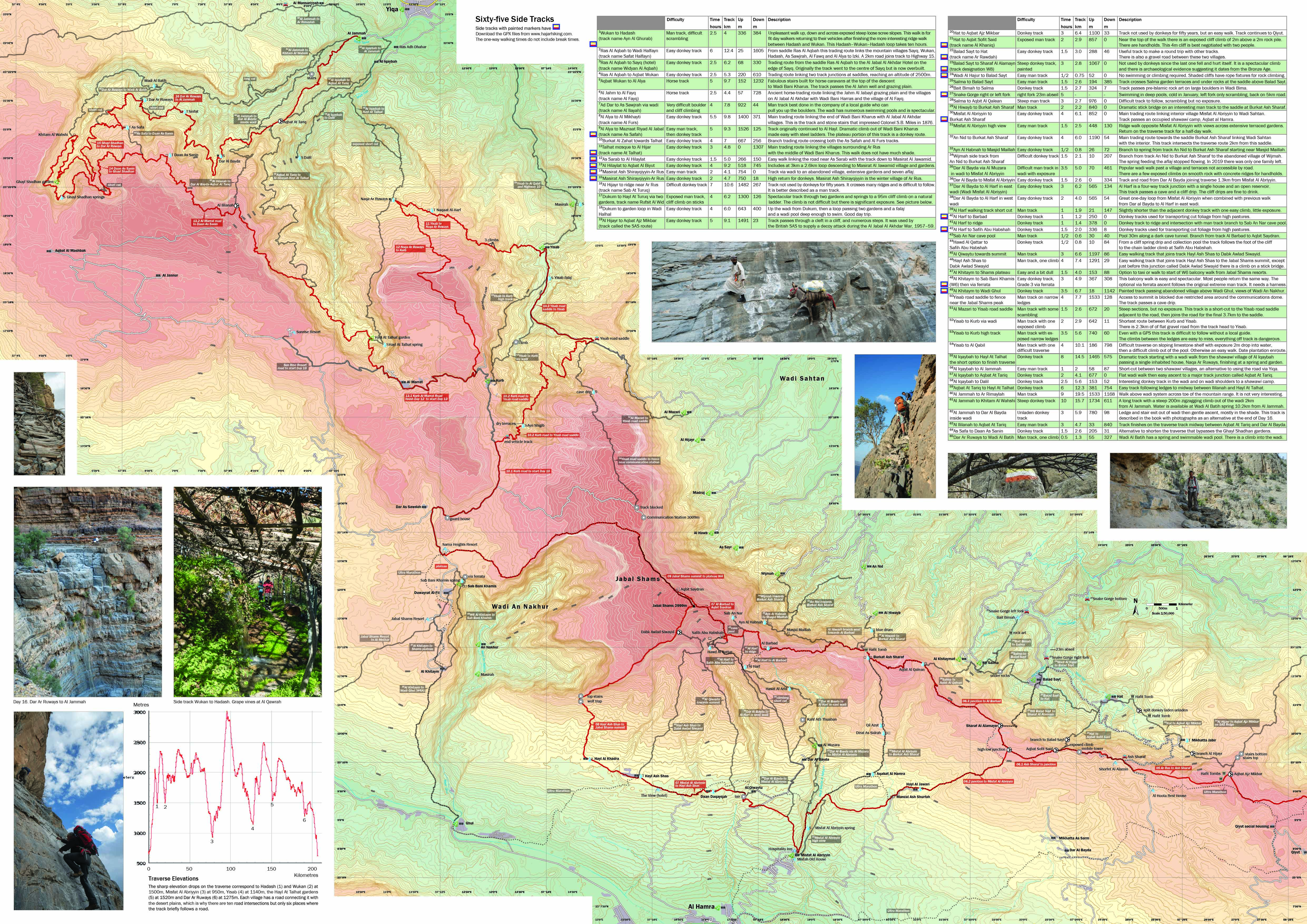
Vertical elevation (metres) of the Western Hajar Traverse plotted against horizontal distance (km). Villages occur at the low points, corresponding to the location of springs. The narrow elevation range of these springs is controlled by geology: rainwater stored in the porous limestone of the mountain tops is forced to the surface by underlying impermeable rock, where the boundary between the two formations is exposed on the north-facing escarpment (steep mountain face) between 1000 and 1500 m elevation.

The six sharp elevation drops on the Western Hajar Traverse correspond, from left to right, to the villages Hadash (1) and Wukan (2) at 1500 m, Misfat Al Abriyyin (3) at 950 m, Yisab (4) at 1140 m, the Hayl At Talhat gardens (5) at 1520 m, and the shawawiya camp Dar Ar Ruways (6) at 1275 m. Apart from Misfat Al Abriyyin, these settlements lie partway down the north-facing escarpment near springs. The springs occur where the geological unconformity (geological boundary) between the Mesozoic rocks and the underlying Precambrian sequence intersects the surface. This angular unconformity generally appears between 1000 m and 1500 m elevation, exposed by erosion, which is why many villages and gardens are located at this level. Rainwater accumulates in the porous Mesozoic carbonate rocks and flows downward until it reaches the impermeable Precambrian basement, where it is forced to emerge as springs. Because the Mesozoic carbonate sequence is thousands of metres thick, it acts as a vast natural reservoir that sustains the springs during long periods of dry weather.

The shortest routes between the villages cross the high plateaux above 2000 m, which is why the elevation profile shows steep drops to the villages below. As a result, much of the traverse involves a series of ascents and descents of 500–1000 m along the escarpment between villages, as shown on the elevation diagram. Each village has a road connecting it with the desert plains below the mountains. The traverse therefore intersects roadheads at ten locations, but follows a road for short distances in only six places.

Start and Finish

The start and finish of the Western Hajar Traverse are shown on the Google Map below, together with the fastest road route between them. The start is at Al Afyah, on the eastern edge of the Western Hajar Mountains. This village lies in the Sumail Gap, a natural east–west pass through the Hajar Mountains that connects the coastal plain with the desert interior and the main inland town of Nizwa. Al Afyah is about 100 km southwest of Muscat International Airport, an hour’s drive on tarmac along Nizwa Highway 15, which follows the Sumail Gap. Transport options include taxis, shared taxis, or maxi taxis (minibuses locally known as baisa buses, named after the small coin used for the fare). Shared taxis and baisa buses will drop you about 1 km from the start of the traverse on the Muscat–Nizwa highway. Day 1 is a ten-hour walk, so it is best to start at dawn. This is not always possible with baisa buses, so it is wise to book a private taxi to ensure an early start. The village of Al Afyah is also known as Hamma, so to avoid confusion you should use your Garmin to direct the driver to the start of the traverse. Alternatively, you can start later and camp on the plateau at the small cave, making Day 1 a two-day walk. There is no water until Hadash, so if you plan to do this you should begin with at least six litres of water.

The traverse finishes at Yiqa, about 160 km from Muscat International Airport. Taxis are available from Yiqa to Rustaq, where buses run to Muscat.

On the Google Map showing the start and finish of the Western Hajar Traverse, use Ctrl/Command + scroll to zoom in and out, or pinch with two fingers on a touch screen.
The two chain-ladder climbs and the spring on the high route. The ladders are physically easy to climb, but they feel exposed.

Climate and Tracks

The main walking season runs from mid-November to March. February is often the best month because temperatures remain cool while daylight hours increase after midwinter. Cloud cover is usually minimal, so strong sun protection is essential even in winter despite the cool temperatures. The traverse crosses several mountain microclimates, from warm wadis to high plateaus and the cold summit zone of Jabal Shams. Temperature is the most important weather variable in these arid mountains. Because of the dry air and clear skies, temperature differences between low and high elevations, and between day and night, can be large. In winter the warmest daytime temperatures may reach about 25 °C at the lowest elevations, while temperatures on the summit can fall below freezing, where light snow falls occasionally. Strong winds and rain are rare, although when it does rain it is often accompanied by wind. Because of this, tents are often less useful than expected (except for privacy). There are few reliable fixing points, and heavy rocks are often the only anchors, which may not hold when a tent turns into a sail in the wind. If you want additional weather protection beyond a good lightweight rain jacket, a breathable bivvy bag is often more practical than a tent. Winter weather forecasts for the Western Hajar are reasonably accurate, and there is a weather station online for Jabal Shams. Winter rain is usually light and arrives from the northwest across Arabia, whereas summer monsoon storms from the Indian Ocean can be torrential and may cause flash floods. Check the forecast every three days, and if rain is expected seek shelter in a cave, rock overhang, or shawawi camp and wait for the rain to pass.

Snow occasionally falls on Jabal Shams, and night-time temperatures may fall below 0 °C, so bring a warm sleeping bag and warm layers.
Tracks on the Western Hajar Traverse
Access and Land Use

In the mountains and deserts of Oman there is no formal system of public rights of way, and people may walk freely across the landscape. In practice, people may walk almost anywhere unless a physical barrier indicates private property, such as walls surrounding houses or yards and fences around irrigated gardens. The only restrictions apply to routes that pass directly through villages, where men from neighbouring villages are normally expected to seek permission. This does not apply to tourists. Most of the tracks on the traverse cross land used by the shawawiya, semi-nomadic pastoralists who browse goats and collect firewood and medicinal plants. The customary rights to use the resources of this territory, known as an isbah, belong to the shawawiya and are traditionally associated with particular families. However, there are no restrictions on others crossing this territory.

Types of Mountain Tracks

The traverse follows a remarkable variety of historic tracks. Some have not been used for generations, while on others you will still see donkeys carrying supplies. These include major and minor donkey caravan routes and donkey tracks used by unladen animals. The major donkey trading routes have their own names and are built with stone steps and retaining walls wide enough for a laden donkey. Barriers made from stones and sticks keep the animals away from overhanging cliffs where there is insufficient clearance for their loads. Unladen donkey tracks contain narrow or height-limited sections that cannot be used by a laden animal. One of the side routes is a packhorse trail, although it has not been used by horses for more than three hundred years. It includes elaborate stone staircases built for the less robust but faster horse caravans. Man tracks—a term translated from Arabic—link villages at similar altitudes that produce the same crops and therefore have little need for trade. Instead they were used mainly for social contact between communities, such as visits, weddings and funerals. Because pack animals were not required, these paths often follow the most direct line across the terrain and may involve scrambling. Caravan routes still in use are easily identified by a continuous line of donkey droppings and carry provisions to semi-nomadic pastoral settlements not served by roads.

On the tracks between the summer and winter villages of settled farmers, the stones have been polished smooth by hundreds of years of footfall. These shiny rocks remain visible even when a track is disused and overgrown with acacia bushes. Six of the tracks on the traverse have recently been waymarked with stripes of yellow, white and red, or with reflective green dots from recent ultra-marathon races, for which GPS navigation is not required. A few other tracks show earlier and less frequent applications of paint. All the paint marks are reliable, although different vintages sometimes follow slightly different routes. High cairns on cliff tops mark the start of steep descents. The most difficult climbs on the traverse are a 2.5 m cliff, which has plenty of handholds, and on the high option a 12 m cliff with a chain ladder. All the climbs are shown in photographs on this website and in the guidebook Wilderness Trekking Oman. The easiest tracks to follow are the old trading routes linking villages to the large market towns below the mountains, to the coast, and to each other when they grow complementary crops. For example, lower warmer villages grow dates, while higher cooler villages grow wheat on sunny terraces, or walnut and pomegranate trees on narrow shaded terraces.

Local Knowledge

Be cautious when asking for directions. A villager from As Sawjrah who accompanied me on my first walk to Ar Rus knew the first 5 km extremely well, as this was within the range of his foraging goats. Beyond that point, the route we followed to Ar Rus was based on his mountain instinct rather than specific knowledge of a track, while my second attempt was 3 km shorter. The shawawi semi-nomadic pastoralists have a much wider knowledge of tracks than settled villagers, as their isbah territories may extend 20 km or more from their homes. At the time of publication, no one person is known to have knowledge of the entire traverse, although this is expected to change. For this reason, it is necessary to be confident using a navigation device to walk the traverse. However, if you prefer not to walk alone, an Omani guide will keep you safe. In practice you would guide the Omani with your navigation device, while the Omani provides company and could obtain help in an emergency.

These are the maps of each day's walk. If printed in actual size the map scale will be 1:50,000. Map Key, Day 1-2, Day 3, Day 4a, Day 4b, Day 5a, Day 5b, Day 6, Day 7, Day 8, Day 9, Day 10, Day 11, Day 12, Day 13a, Day 13b-16a, Day 16b. High Route. All these maps can be purchased in a combined folded A1 format from Cordee map distributors.. They are also available in the free Oman hiking guidebook download (PDF) or purchased in paperback from Nomad Publishing.

Historic track types—donkey caravan routes, unladen donkey tracks, and man tracks—served different purposes and vary in difficulty for recreational walkers.
These are representative examples of some of the most difficult climbs on the Western Hajar Traverse.
Donkeys on the Western Hajar Traverse

Donkeys and a donkey-handler guide can be used for the last four and most remote days of the traverse. They can carry heavy local food and are an interesting experience, although this is not any faster than walking alone. These mountain donkeys are trained to carry loads and know most of the tracks, but neither village donkeys used only for agriculture nor desert donkeys are capable of travelling in the mountains. The only village donkeys you will see on the Western Hajar Traverse are in the extensive terraces at Misfat Al Abriyyin.

Abdullah Al Khambashi and the shawawiya who live in the satellite settlement of Al Jammah, west of Yiqa, have nine mountain donkeys and are keen to use them for tourism. Abdullah and most of the men from his extended family had military careers before retiring. Trekking tourism helps utilise their numerous semi-nomadic campsites and remote gardens. Typical of shawawiya, Abdullah’s family own five simple storehouses in the wadi, as well as their modern house in Al Jammah. There is water and a donkey enclosure at each campsite.

The etiquette section explains what you should and should not pay for, including donkeys, and how much.

Donkeys prefer company, so hiring a pair of compatible donkeys for four hikers is easier to manage than a single donkey. They walk quickly for about four hours and then need to drink, eat and rest for two hours. They are fed hay, which they carry in a bag tied above their load, together with a bowl of dates. Abdullah made a point of remaining completely silent so as not to disturb his donkey while it was drinking. The donkeys must be unloaded during their rest, when they immediately roll on the ground to scratch their backs. This unloading and subsequent loading procedure is done carefully. Five saddle blankets spread the point loads of the saddle tree, which has a pair of wooden loops that fit into two pockets on the fabric saddlebag. The heaviest items are loaded into the saddlebags, then the rest of the load is tied on top, with the hay bag last. If the loaded donkey is lopsided it is balanced by adding rocks to one of the saddlebags. Balance is more important than weight.

The shawawiya will lead or let their donkeys loose depending on the track. They are led when the path climbs steeply or when negotiating something difficult, such as boulders in a wadi. The only time Abdullah threatened his brother’s donkey with a stick was on a track that had not been used for forty years. Two places on this eroded track were too steep for a laden donkey, so we carried the saddlebags ourselves. Most of the donkey tracks from Yiqa are in frequent use and well maintained. When donkeys are not on leads they will walk briskly ahead, then stop and look behind or turn around to face you. Sometimes they will not stop and you have to run to catch up, especially if you pause to take a photograph. They will trot to the destination when close to a familiar campsite. The first few kilometres from their home is the hardest: a solo donkey will exchange bellows with the herd back in the village and try to rejoin them by swerving off the track. The herd, while all in separate enclosures, are in frequent communication.

When donkeys are not required for a caravan they are released for grazing within areas of a wadi enclosed by natural barriers. These barriers, such as cliffs, are augmented with short fences across any ledges where donkey tracks exit the enclosure. These fences, made from a tangle of branches, are called shiggy and function as gates; they must be dismantled and reassembled when travelling along these tracks. A donkey’s working life is typically from three to twenty years.

Loading a donkey, other donkey photographs and a donkey gate.

For the last four and most remote days finishing at Yiqa it is possible to hire a donkey caravan.

Abdullah Al Khambashi +968 9569 8833, donkey owner from Al Jammah, a village 2.4 km west of Yiqa.
Side Routes and Loops on the Western Hajar Traverse

These tables of side routes and loops are in addition to the traverse described in Days 1–16. In total, 604 km of tracks on Western Hajar are described on this website, in the guidebook and in the GPX files, including the main traverse and its side routes. Short excursions mentioned in some of the Day 1–16 chapters are not repeated in these tables.

The three best tracks for a family looking for a short walk to a swim are the 2 km walk from Dukum to the pool at Wadi Al Kawr, the 2.3 km walk from Al Alya to Ad Dar where there is a string of wadi pools and the balcony walk Al Khitaym to As Sab Bani Khamis (W6). The balcony walk has a large pool with a muddy bottom that is 500m further than the abandoned village and above the hanging terraces. There is a cave drip replenishing this pool. This three hour 5 km walk has become so popular there are now hotels near Al Khitaym. There is an alternative to retracing your steps from As Sab Bani Khamis; a Grade 3 via ferrata starting 150 m northeast of the pool at the foot of the cliff up to the Shams plateau.

The side routes do not overlap with each other or with any of the traverse tracks. Many of them branch from other tracks and only a few have waymarks. Twenty loops have been created using these side routes and portions of the traverse, and are described in the second table following the side routes table. GPX files of the traverse, side routes, loops and waypoints are available for download. These can be combined in Garmin BaseCamp or similar software to create your own loops.

The times provided for these tracks are one-way walking times and do not include breaks. They allow for some time spent referring to a navigation device, although this will depend on the hiker’s skill. It is recommended to employ a guide for your first walk to become familiar with the terrain, and to carry the paper map together with a satellite navigation device.

Several donkey tracks have man-track shortcuts that are not listed in this table but are shown on the maps and in the GPX files. Most of these shortcuts are only marginally shorter and, because of their increased difficulty, may not save any time. They are included on the maps to avoid confusion when passing the junction. Until you are familiar with the terrain, it is prudent to stay on donkey tracks.

The side routes in this table include nearly all the donkey trading routes that intersect or lie near the traverse, but they do not form a complete list of all donkey tracks in the Western Hajar. Historically important routes not included are the trading routes ascending the south side of the mountains from the interior, for example those up Wadi Kamah, Tanuf, Muaydin and Imty, most of which have their own names. The track from Imty is called Alerurqub. These routes are excluded because they lie far from the traverse and, being on the more developed side of the mountain range, are sometimes crossed by roads.

Side routes that require ropes are also excluded. For example, the route from Wadi An Nakhur to Jabal Shams involves a 2200 m ascent, including two exposed 10 m cliffs. Once the route has been surveyed and anchor points installed, it will be added to the GPX files and digital maps on this website. Walking parties on this route will always require one climber to establish a belay for the others.

Side routes crossing the traverse listed from east to west Difficulty Time (hours) Track (km) Up (m) Down (m) Description
Wukan man track to Hadash (track name Ayn Al Ghurab) Man track, difficult scrambling 2.5 4 336 384 An unpleasant walk up, down and across exposed, steep, loose scree slopes. This route is suitable for fit day walkers returning to their vehicle after completing the more interesting ridge walk between Hadash and Wukan. The Hadash–Wukan–Hadash loop takes about ten hours.
Ras Al Aqbah to Wadi Halfayn (track name Safat Halfayn) Easy donkey track 6 12.4 25 1605 From the saddle Ras Al Aqbah this trading route links the mountain villages of Sayq, Wukan, Hadash, As Sawjrah, Al Fawq and Al Alya to Izki. A 2 km road section joins the track to Highway 15.
Sayq (hotel) to Ras Al Aqbah (track name Widyan Al Aqbah) Easy donkey track 2.5 6.2 330 68 Trading route from the Jabal Akhdar Hotel on the edge of Sayq to the saddle Ras Al Aqbah. Originally the track started in the centre of Sayq but is now overbuilt.
Aqbat Wukan to Ras Al Aqbah Easy donkey track 2.5 5.3 610 220 Trading route linking two saddles with track junctions reaching an altitude of 2500 m
Al Alya to Aqbat Wukan Horse track 5 9.7 1232 152 Fabulous stone stairs at the top of the ascent from Wadi Bani Kharus, built for horse caravans. The track passes the Al Jahm well and the grazing plain of Jahm Al Jabayl.
Al Jahm to Al Fayq (track name Al Fayq) Horse track 2.5 4.4 57 728 Ancient horse-trading route linking the grazing plateau and the villages of Al Jabal Al Akhdar with Wadi Bani Harras and the village of Al Fayq.
Ad Dar to As Sawjrah via wadi (track name Al Ilayah) Very difficult, boulder and cliff climbing 4 7.8 922 44 Man track best done in the company of a local guide who can pull you up the boulders. The wadi has numerous swimming pools and is spectacular
Al Alya to Al Mikhayti (track name Al Furs) Easy donkey track 5.5 9.8 1400 371 Main trading route linking the end of Wadi Bani Kharus with Al Jabal Al Akhdar villages. This is the track and stone stairs that impressed Colonel S.B. Miles in 1876
Al Alya to Mazraat Riyad Al Jabal (track name As Safah) Easy walking track, then donkey track 5 9.3 1526 125 Track originally continued to Al Hayl. Dramatic climb out of Wadi Bani Kharus made easy with steel ladders. The plateau portion of this track is a donkey route
Burkat Al Zahat towards Talhat Easy donkey track 4 7 667 256 Branch trading route crossing both the As Safah track and Al Furs track
Talhat mosque to Al Hijar (track name At Talhat) Easy donkey track 3 4.8 0 1307 Main trading route linking the villages surrounding Ar Rus with the middle of Wadi Bani Kharus, and then to Ar Rustaq. This walk does not have much shade
Ar Rus to Masirat Ash Shirayqiyyin Easy man track 2 4.1 0 754 Track via wadi to abandoned winter village and extensive gardens with seven springs and aflaj.
Masirat Ash Shirayqiyyin to Ar Rus Easy donkey track 2 4.7 18 750 High return for donkeys. Masirat Ash Shirayqiyyin is the winter village of Ar Rus
Al Hilaylat to Aqbat Al Biyut Easy donkey track 4 9.2 518 745 After 3 km the track passes the abandoned village of Masirat Al Jawamid and its irrigated gardens.
Al Hilaylat to As Sarab Easy donkey track 1.5 5 150 266 Easy walk linking As Sarab and Ar Rus with the excursion to Masirat Al Jawamid.
Dukum Hayl At Turuq via gardens (track called Rufsit Al Wid) Exposed man track, cliff climb on sticks 4 6.2 1300 126 Spectacular track through two gardens and springs to a 95 m cliff climb on a natural ladder. The climb is not difficult but there is significant exposure
Dukum to garden loop in Wadi Halhal Easy donkey track 4 6 643 400 One way up the wadi from Dukum, then a loop passing two gardens and aflaj, and a wadi pool deep enough to swim. A good day trip.
Ridge near Ar Rus to Al Hijayr (track name Sab At Turuq) Difficult donkey track 7 10.6 267 1482 Track not used by donkeys for fifty years. It crosses many ridges and is difficult to follow. Better described as a man track.
Aqbat Ajz Mikbar to Al Hijayr (track called the SAS route) Easy donkey track 5 9.1 23 1491 Track passes through a cleft in a cliff, and numerous steps. It was used by the British SAS to supply a decoy attack during Al Jabal Al Akhdar War, 1957–59.
Hat to Aqbat Ajz Mikbar Donkey track 3 6.4 1100 33 Track not used by donkeys for fifty years, but easy walk. Track continues to Qiyut.
Aqbat Sofit Said to Hat (track name Al Khaniq) Exposed man track 2 2.9 0 857 Near the top of the walk there is an exposed cliff climb of 2 m above a 2 m rock pile. There are handholds. This 4 m cliff is best negotiated with two people.
Balad Sayt to Hat (track name Ar Rawdah) Easy donkey track 1.5 3 288 46 Useful track to make a round trip with other tracks. There is a gravel road between these two villages.
Balad Sayt to Sharaf Al Alamayn (track name W8) Steep donkey track, waymarked 3 2.8 1067 0 Not used by donkeys since the last one fell and hurt itself. It is spectacular, and there is archeological evidence suggesting it dates from the Bronze Age.
Salma to Balad Sayt Easy man track 1.5 2.6 194 385 Track crosses Salma garden terraces and short tunnel at saddle above Balad Sayt
Bait Bimah to Salma Donkey track 1.5 2.7 324 7 Track passes pre-Islamic rock art in Wadi Bima
Salma to Aqbit Al Qalean Steep man track 3 2.7 976 0 Difficult track to follow, scrambling with no exposure
Wadi Al Hajur upper Snake Gorge Easy man track 0.5 0.75 52 0 No swimming or climbing required. Shaded cliffs have rope fixtures for rock climbing
Snake Gorge right or left fork right fork 23m abseil 5       Swimming in deep pools, cold in January, left fork only scrambling, back on 5km road
Al Hiwayb to Burkat Ash Sharaf Man track 2 2.2 840 0 Dramatic stick bridge on an interesting man track
An Nid towards Burkat Ash Sharaf Easy donkey track 4 6 1190 54 Main trading route to the saddle Burkat Ash Sharaf linking Wadi Sahtan with the interior. This track intersects the traverse route 2 km from the saddle
Misfat Al Abriyyin to Burkat Ash Sharaf Easy donkey track 4 6.1 852 0 Main trading route linking interior village Misfat Al Abriyyin to Wadi Sahtan. Track passes an occupied shawawi camp, Aqbat al Hamra
Wijmah from junction on track An Nid to Burkat Ash Sharaf Difficult donkey track 1.5 2.1 10 207 Branch from track An Nid to Burkat Ash Sharaf to the large abandoned village of Wijmah
Ayn Al Habnah to Masjid Maillah Easy donkey track 0.5 0.8 26 72 Branch to spring from track An Nid to Burkat Ash Sharaf starting near Masjid Maillah
Misfat Al Abriyyin high view Easy man track 1.5 2.5 448 130 Ridge walk opposite Misfat Al Abriyyin with views across terraced gardens. Return on the traverse track for a half-day walk
Dar Al Bayda to Misfat Al Abriyyin via Al Muzara in wadi Difficult man-track in wadi with exposure 3.5 5 70 461 Popular wadi walk past village and terraces without road. There are a few exposed climbs on smooth rock with concrete ridges for handholds
Dar Al Bayda to Misfat Al Abriyyin Easy donkey track 1.5 2.6 0 344 Return walk from Al Muzara wadi scramble. Track joins traverse 1.3 km from Misfat
Dar Al Bayda to Al Harf in east wadi Easy donkey track 3 6.2 565 134 Al Harf is a four-way track junction with a single house and open reservoir. This track passes a cave and a cliff drip. The cliff drips are fine to drink
Dar Al Bayda to Al Harf in west wadi Easy donkey track 2 4 565 54 Great one-day loop when combined with previous walk from Dar Al Bayda to Al Harf in east wadi
Al Harf walking track shortcut Man track 1 1.9 21 147 Slightly shorter track with one easy climb, little exposure
Al Harf to Al Barbad (also known as Al Murabadh) Donkey track 1 1.24 250 0 Donkey track to mountain hut for public use
Al Harf to junction on track Al Barbad to Aqbit Saydran Donkey track 1 1.4 378 0 Donkey tracks used for transporting cut foliage from high pastures
Al Harf to Safih Abu Habshah Donkey track 1.5 2 336 8 Donkey tracks used for transporting cut foliage from high pastures
Al Qiwaytu towards summit Man track 3 6.6 1197 86 Easy walking track that joins track Hayl Ash Shas to Dabk Awlad Siwayid
Hayl Ash Shas to Dabk Awlad Siwayid Man track, one climb 4 7.4 1291 29 Easy walking track that joins track Hayl Ash Shas to the Jabal Shams summit. Just before this track junction called Dabk Awlad Siwayid there is a climb on a stick bridge
Sab An Nar cave pool Man track 0.5 0.6 30 30 Pool 30 m along dark cave tunnel. Branch from track Al Barbad to Aqbit Saydran
Hawd Al Qattar to Safih Abu Habshah Donkey track 0.5 0.8 10 84 Cliff spring drip and collection pool. Branch from track Al Harf to Safih Abu Habshah with loop return on 700 m track directly to chain climb at Safih Abu Habshah
Wadi Ghul to Al Khitaym (W6A) Donkey track 3.5 6.7 1142 18 Waymarked track passing an abandoned village above Wadi Ghul, views of Wadi An Nakhur
Al Khitaym to As Sab Bani Khamis (W6) then via ferrata Easy donkey track, Grade 3 via ferrata 3 4.9 367 308 This balcony walk is easy and spectacular. Most people return the same way. The optional via ferrata ascent follows the original extreme man track. It needs a harness
Al Khitaym to the Jabal Shams plateau Easy and a bit dull 1.5 4 153 88 Option to taxi or walking on the road to start of W6 balcony walk from Shams resorts
Jabal Shams Resort to Al Mnthar Easy donkey track 3.0 6.9 7 1098 Descent on dip slope to tarmac road leading to Ghul
Yisab road saddle to securiy fence near Jabal Shams peak Man track on narrow ledges 4 7.7 1533 128 Access to summit is blocked due restricted area around the communications dome. Track passes cave drip
Al Mazari to Yisab road saddle Man track with some scambling 1.5 2.6 672 20 Steep sections, but no exposure. Track shortcut to Yisab road saddle, then 3.7 km road to where two other tracks start from the Yisab road saddle
Yisab to Kurb via wadi Man track with one exposed climb 2 2.9 642 11 Shortest route between Kurb and Yisab. There is 2.3 km of flat gravel road from the track head to Yisab
Yisab to Kurb high track Man track with exposed narrow ledges 3.5 5.6 740 60 Even with a GPS this track is difficult to follow without a local guide. The climbs between the ledges are easy to miss, and everything off track is dangerous
Yisab to Al Qabil Man track with one difficult traverse 4 10.1 186 798 Difficult traverse on sloping limestone shelf with exposure 2 m drop into water, then a difficult climb out of the pool. Otherwise an easy walk. Date plantation enroute
Hayl At Talhat to Al Iqaybah, part of the shorter option detailed in the traverse summary table Donkey track 7 14.5 575 1465 Dramatic track passing a single inhabited house, Naqa Ar Ruways, finishing with an easy wadi walk to the shawawi village of Al Iqaybah that is 4 km by gravel road to Yiqa
Branch to Aqbat At Tariq Donkey track 6 12.3 381 754 Dramatic and easy track following ledges on the opposite side of the previous track
Aqbat At Tariq to Al Iqaybah Donkey track 2 4.1 0 677 Easy descent then flat wadi walk
Al Iqaybah to Dalil Donkey track 2.5 5.6 153 52 Interesting donkey track inside and on wadi shoulders to a shawawi camp
Al Iqaybah to Al Jammah Easy man track 1 2 58 87 shortcut between two shawawi villages, alternative to using the road via Yiqa
Al Allahlanah to Aqbat At Tariq Easy man track 2.5 4.7 33 840 Track branch starts midway between the traverse track Aqbat At Tariq to Dar Al Bayda
Al Jammah to Khitam Al Wahshi Steep donkey track 10 15.7 611 1734 A long track with a steep 200 m zigzaging climb out of the wadi 2 km from Al Jammah. Water is available at Wadi Al Batih spring 10.2 km from Al Jammah
Al Jammah to Dar Al Bayda inside wadi Unladen donkey track 3 5.9 780 98 Ledge and stair exit out of wadi then gentle ascent, mostly in the shade. This track is described with photographs as an alternative at the end of Day-16
Al Jammah to Ar Rimaylah Man track 9 19.5 1533 1168 Walk above wadi system across toe of the mountain range. It is not very interesting
Daan As Sanin to As Safa Donkey track 1.5 2.6 31 205 Alternative to shorten the traverse bypassing Ghayl Shadhan gardens
Dar Ar Ruways to Wadi Al Batih Man track, one climb 0.5 1.3 55 327 Wadi Al Batih is a spring and swimmable wadi pool. There is a climb into the wadi
Side Routes from the Western Hajar Traverse, shown on the overview map. GPX files are available to download in groups arranged east to west.
Examples of difficult climbs on some of the side routes.
Loop walks using side routes and portions of the traverse Difficulty Days Track (km) Up (m) Down (m) Description including water
Al Afyah to Wadi Halfayn via Hadash Difficult scrambling to Hadash, then a donkey track 2 29.8 2287 2311 There is water at Hadash, Al Manakhir and at the end of the descent into Wadi Halfayn where you can swim. There are baisa buses and taxis on the 5 km of highway between the finish at the entrance to Wadi Halfayn and Al Afyah. This loop includes Day 1 described on pages 86 to 97. Maps are on pages 98 and 99.
Hadash loop via Wukan Donkey track out, scrambling on return 1 13.7 1247 1264 Allow 10 hours. There is water at Wukan and Al Qawrah. It is an easy walk to Wukan, which is Day 2 described on pages 100 to 107, but the return to Hadash has some steep scree climbs. Map on page 98.
Wukan high loop A scramble up a steep slope to the saddle, then a donkey track 1 11.8 1063 1063 There is tank water at Aqbat Wukan 300 m beyond the saddle above Wukan, although Aqbat Wukan is not on the loop. This is a high walk, with a minimum altitude of 1500 m, so suitable for warmer temperatures. Map on page 119.
Al Alya loop via As Sawjrah All donkey track 2 28.5 2108 2127 There is clean well water at Al Jahm, tank water at Aqbat Wukan, spring water and The Suwgra guest house at As Sawjrah, dam water at Burkat Al Zahat and spring water at Ad Dar where the pools are large enough for a swim. Maps on page 118 and 119.
Halal gardens loop Donkey track 0.5 7.7 643 643 There is spring water and a swimming pool at Wadi Al Kawr, and springs at Suhub and Halhal gardens. Map on page 134.
Al Hijayr loop This is all a donkey track, though half of the loop is difficult to follow 2 29.3 2122 2109 There is no water. This is a donkey track but the east half of the circuit has not been used for fifty years and is better described as a man track. Maps on page 134 and 135. A shorter circuit ascends from Dukum instead of Al Hijayr, but there is an exposed though non-technical climb before reaching the ridge (see photo on page 229).
Hat loop One exposed climb 1 15.8 1259 1259 A long one-day walk. There is tank water at Mikhatta Jabir and the hotel Shorfet Alalamin is near halfway. There is an exposed and difficult climb near the start of the descent off the ridge above Hat (see photo on page 243). Maps on pages 136 and 147.
Balad Sayt loop via Hat One exposed climb 1 10.7 1235 1235 There is no water. There is an exposed and difficult climb near the start of the descent off the ridge above Hat (see photo on page 243). Map on page 147.
Balad Sayt loop via Salma Man track, steep but not exposed 1 12 1538 1538 There is spring water at Salma and dam water under rocks at Aqbit Al Qalean (see photo on page 145). The cliff between Salma and the ridge is an infrequently used man track, not exposed but steep and hard to follow. Maps on page 146 and 147.
Misfat Al Abriyyin summit loop Donkey track, except for two chain ladders 2-3 37.4 2746 2746 There is tank water at Aqabat Al Hamra, dam water at Qil Azut, Burkat Ash Sharaf and Al Barbad, (also known as Al Murabadh) a 600 m diversion to a spring at Sab An Nar, and water at villages Hayl Al Khadra and Hayl Ash Shas and the hotel The View. Maps on pages 154, 155 and 162. This loop is described in Days 6 to 8, pages 138 to 163.
Misfat Al Abriyyin high loop Easy walk 0.5 5 466 466 View over the Misfat Al Abriyyin terraces and the star clock towers. Map on page 154.
Misfat Al Abriyyin wadi loop Slippery scramble 1 10.9 680 680 There is water in the wadi with a few exposed slippery climbs. Map on page 154.
Dar Al Bayda loop All donkey track 1 10.3 687 687 There is a wall drip at Hasat Al Arid and a tank at Al Harf. Map on page 154.
Al Hiwayb to An Nid near loop Man track ascent, donkey track descent 1 9.2 870 1231 There is a spring Ayn Al Habnah on a 500 m diversion. The circuit is incomplete; there is 4 km of steep gravel road between the two track heads at An Nid and Al Hiwayb. Maps on page 154 and 155.
Hayl Ash Shas loop One exposed climb 1 16.3 1384 1384 There is no water, an exposed branch bridge at Dabk Awlad Siwayid, otherwise easy. Map on page 162.
Kurb loop via yisab Three climbs 3 31.4 2194 2194 This circuit is described in detail with maps on pages 172 to 191.
Wadi Yiqa loop Donkey track 2-3 35.7 2135 2135 Tank water at Naqa Ar Ruways and a spring at Hayl At Talhat. Maps on pages 202 and 203.
Al Jammah one-day loop Unladen donkey track 1 11.4 850 850 There is no water, with some walking inside a shaded wadi on an unladen donkey track. This walk is described on pages 224 to 227. Map on page 211.
Al Jammah five day loop Donkey track, with a few easy climbs 5 72 3480 3480 This is four days of the traverse plus the one-day option described in detail with maps on pages 192 to 227.
Wadi Taysa loop Donkey track, with one easy climb 2 27.4 1554 1554 There are springs at Wadi Al Batih and Dar Al Bayda, and tanks at Dar Ar Ruways and Sinfat. Map on page 211.
Loops from sections of the traverse and side routes. GPX files of these 20 loops are available to download.
Ultra Marathon tracks in Western Hajar Traverse

Four ultra marathon tracks have been created in the Western Hajar Mountains; 10, 50, 130 and 170 km, which overlap with parts of Days 5 to 9 of the traverse and corresponding side routes. They all have reflective green dots for night running so they can be followed without a navigation device. Red dots indicate incorrect routes. In places these marathon tracks take a less scenic but smoother route than all the other tracks, and portions of these tracks are on gravel roads. They are shown on the 1:50,000 maps as a dotted grey line. GPX files of these ultra marathon tracks are also available for download. These ultra marathon tracks were surveyed and marked by OmanSail in 2018 and 2019, an organisation responsible for bringing international sporting events to Oman. The 170 km track uses the two chain ladders that were installed to make the Day 6 high route possible for a non-climber carrying a pack.

Ultra Marathons Difficulty Fastest Time (hours) Track (km) Up (m) Down (m) Description
Omansail 10 km Starter running track 0.8 10.5 924 923 Loop from Al Hamra including a section of road
Omansail 50 km Moderate running track 5.5 52 2517 2517 A loop on the ridge and south dip slope between Qiyut, Misfat Al Abriyyin and Ash Sharaf
Omansail 130 km Extreme running track 18 126 7283 7205 Starts from Birkat Al Mawz up Wadi Muaydin on the south side of the mountains heading north to the mountain spine via two deep wadi excursions near Masirat Al Jawamid and Masirat Ash Shirayqiyyin, turns west along the ridge sometimes dropping south by several hundred meters off the historic trading route between Ar Rus and Ash Sharaf as in Day 5 where the terrain is less scenic but smoother for night running, loops north off the ridge to Balad Sayt by road and back by track, then more ridge before finally descending south to Al Hamra via Misfat Al Abriyyin. Portions of the track are on roads
Omansail 170 km Very extreme running track 36 168 10052 9974 Extends the 130 km track with the addition of the Day 6 high optional route to Jabal Shams using the chain ladders, then Day 9, side route down the edge of Wadi An Nakhur to the gravel plain at the base of Wadi Ghul, back up the dip slope to Hayl Ash Shas finishing with Day 7 in reverse to Misfat Al Abriyyin and down to Al Hamra
Four ultra-marathon courses marked with small reflectors, with GPX files available for download.
4WD Access Roads

The maps in the guidebook and separate folded map show 4WD access roads on both the north and south of the mountains. These connect to many of the side routes from the traverse. GPX files of these roads are available to download. They will be useful if you have a support team who are driving a 4WD vehicle.

Water and Provisions

Drinking water is available at each campsite other than the summit of Jabal Shams, and on some days also while walking, with locations listed by day in the following table. There are three sources of water: public village taps, serviced accomodation, and remote water locations, which are indicated in blue text. Remote water sources include springs, cliff drips, cave pools, tanks, open reservoirs, and wadi dams. These sources are shown on three 1:400,000-scale maps: the overview map, serviced accomodation map, and the map of remote water locations. The higher resolution 1:50,000-scale maps in the chapters describing each day’s walk display all water sources on the same map, and they are also included in the GPX file of waypoints.

Drinking Water Treatment

Aini falaj water comes from springs and is described in detail in the Irrigation chapter of the guidebook Wilderness Trekking Oman. Water from springs, cave pools and cliff drips does not require treatment. Water from the public taps in Hadash and Wukan comes from nearby springs, while water from the villages of Hayl Ash Shas, Hayl Al Khadra, Kurb and Al Marrat comes from regularly used tanks and tastes fine.

All tanks in semi-nomadic pastoralists’ campsites, for example above Misfat Al Abriyyin and to the west of Jabal Shams, are large rainwater tanks that may have a slight plastic taste due to infrequent use. Treating this water is optional. The tap for these tanks is usually removed and placed nearby to prevent accidental emptying, for example by a goat nibbling it. This tank water is available for any traveller to drink sparingly. These semi-nomadic pastoral camps are described in the Culture chapter. The only tank water you are likely to use will be during the last four days, and it is advisable to forewarn Abdullah Al Khambashi on +968 9569 8833, or one of his relatives in Al Jammah who own the tanks.

Water from open reservoirs and wadi dams should be filtered and then boiled or treated before drinking, for instance the water at Burkat Ash Sharaf and Al Barbad (also known as Al Murabadh) on the high option approaching the summit.

Days Destination Water at start Water midway -- Water in blue text is on map of remote water locations
1 Al Afyah to Hadash Al Afyah falaj none
2 Hadash to Wukan Public tap at the carpark or Hadash Guest House spring near Wukan
3 Wukan to As Sawjrah Wukan public tap, falaj, or Sama Wakan Heritage Lodge Aqbat Wukan tank after two hours
4 As Sawjrah to Ar Rus As Sawjrah spring or guest house THESUWGRA none
5 Ar Rus to Ash Sharaf Ar Rus public tap at mosque or Alila Hotel none
6 Ash Sharaf to Misfat Al Abriyyin Shorfet Al Alamin hotel, Al Hoota Rest House, roadside cafe Hayl Al Jawari tank after four hours
7 Misfat Al Abriyyin to Hayl Ash Shas Misfat Al Abriyyin has at least four guest houses, and falaj Daan Daqayqah tank after two hours
8 Hayl Ash Shas to Jabal Shams summit The View hotel, the cemetery before Hayl Al Khadra Hayl Al Khadra tank after one hour
9 Jabal Shams summit to plateau none none
10 Kurb road to Yisab road saddle Sama Heights Resort or Jabal Shams Resort Ayn Shigib spring after two hours
11 Yisab to Naqa Ar Ruways Yisab falaj Naqaat Al Harf tank after seven hours
12 Naqa Ar Ruways to Kurb Naqa Ar Ruways tank none
13 Al Marrat road to Daan As Sanin Sunrise Resort or Sama Heights Resort, or Al Marrat tank Hayl At Talhat falaj after two hours
14 Daan As Sanin to Ghayl Shadhan Daan As Sanin tank Ghayl Shadhan spring after six hours
15 Ghayl Shadhan to Dar Ar Ruways Ghayl Shadhan tank As Safa tank after three hours
16 Dar Ar Ruways to Al Jammah Dar Ar Ruways tank Sinfat tank after one hour, Dar Al Bayda spring after two hours
Water locations on the two options
6 Ash Sharaf to Al Barbad (also known as Al Murabadh) Shorfet Al Alamin hotel or Al Hoota Rest House Aqbit Al Qalean open reservoir after four hours, Burkat Ash Sharaf open reservoir after five hours
7 Al Barbad to Jabal Shams summit Al Barbad open reservoir Sab An Nar cave pool in one hour, Hawd Al Qattar cliff drip in two hours
13 Al Marrat road to Al Iqaybah Sunrise Resort or Sama Heights Resort, or Al Marrat tank Hayl At Talhat falaj after two hours, Naqa Ar Ruways tank after five hours
Drinking water on the Western Hajar Traverse, shown on the maps of remote water locations and guest house and hotel locations.
Examples of different sources of drinking water.
Provisions

You should treat the Western Hajar Traverse as an expedition because there are only a few villages with shops where fresh supplies can be purchased, and village shop opening hours are inconsistent. The only reliable town centre with provisions near the traverse is Al Hamra, which is a 15-minute taxi ride for the 7 km drive down a tarmac road from Misfat Al Abriyyin, reached at the end of Day 6.

Lightweight freeze-dried meal packets are ideal because water is available every night. Before the traverse it is advisable to determine how many meals you will need to sustain continuous eight- to ten-hour walking days for sixteen days, and to test how many you can comfortably carry. This will determine how many supply rendezvous you will need to replenish your food.

Your carrying capacity will depend on the weight of your pack, which is partly determined by how much drinking water you carry. Daily water consumption will depend on the month you are walking. Three litres per day is sufficient in the optimum walking season from mid- November to March. Load your pack, including this water, to determine how many days of food you are comfortable carrying, remembering that there are 1000 m climbs. A reasonable pack weight is about 18 kg.

You should carry enough food and water for a minimum of two days to complete the summit section. Using donkeys is a possibility for the remote four-day section at the end of the traverse because they can carry heavier local food. One donkey can carry food supplies for two walkers.

The best way to organise provisions for the traverse is to purchase freeze-dried meals in your home country and send them by tracked delivery to your chosen guest house or hotel rendezvous at least a month before your trip. Include a letter with your name, expected arrival date, and a request for email confirmation when the parcel is received. The following section describes which guest houses and hotels have previously received food parcels.

An alternative is to rely on friends or family if you are accompanied by non-walkers. The road network makes it feasible for them to hire a vehicle and meet you at some of the villages with your food supplies. Driving instructions to each road intersection are included in the daily track descriptions.

Cooking

Using camping gas to boil water for freeze-dried food is recommended but not essential. Camping gas can be purchased in department stores in Muscat. Alternatively there are plenty of dry fallen branches for fires, which are easily lit but should be used judiciously. Use existing fireplaces whenever possible and note that cutting live hardwood is illegal because of conservation measures. Open fires may become restricted in parts of the mountain range as further environmental protection measures are introduced.

Camping, Packing and Serviced Accomodation

You do not need to carry a tent or bivy bag because only two campsites are low enough for mosquitoes and dew is usually light. However, some walkers in their feedback recommend bringing an ultralight tent or bivy bag to avoid dew settling on sleeping bags. Whether this justifies carrying the additional weight and volume is a personal choice. Our family always slept under the stars.

Wild camping is permitted in Oman and is the only option for the second half of the traverse where you do not pass a road or serviced accommodation. There are no fixed campsites. The terrain is mostly rock, so you will need to choose a site carefully. At high elevations it is best to sleep under juniper trees on beds of fallen needles. Elsewhere, disused goat enclosures often have soft layers of dried droppings. Ledges under rock overhangs or caves frequently contain comfortable layers of dust. Wild donkeys also create stone-free dust bowls when they roll on their backs, conveniently sized for one person.

There are a few natural pools suitable for swimming, but it is not acceptable to bathe in the irrigation channels known as aflaj. For showering, plan to use serviced accommodation, some of which offer washing and toilet facilities for campers.

Pests

The main pests are mosquitoes, but these occur only on the two nights spent at lower elevations near exposed water: Misfat Al Abriyyin (950 m) and Yisab (1140 m). Mosquitoes can be avoided at Misfat Al Abriyyin by staying at one of the guest houses, but mosquito repellent is recommended for the overnight camp at Yisab. Malaria tablets are not necessary.

Other noxious animals exist but rarely cause problems. Scorpions live under rocks, which you may disturb when preparing fireplaces. You may encounter racers, which are non-venomous snakes sometimes seen near or in water. All other snakes should be treated as venomous, although most are rarely seen. None of the villages on this route keep dogs. Goats are determined to be fed but will not disturb you at night; however, do not leave edible belongings unattended during the day or they will eat them. It is best not to feed them.

Examples of campsites.
Packing

The suggested packing list corresponds to the photograph showing the contents of my pack. A 65-litre pack is large enough. A –20 °C down sleeping bag is recommended. If you sleep wearing only light walking clothes in freezing conditions, you will need this rating to remain comfortable.

Therm-a-Rest NeoAir mats are designed to be used inside a tent, so you need to provide equivalent protection from thorns and sharp rocks. For example, placing a rubber sleeping mat underneath will protect the inflatable mat and provide additional cushioning. With this double-mat combination you only need a reasonably flat surface on which to sleep; even hard rock can be comfortable.

The rubber mat will not fit inside your pack, so the ends will protrude when it is secured under the pack’s top cover. Acacia thorns may rip it during the walk, so it will probably need replacing after the sixteen-day traverse.

Pack Contents
Camping gear that fits inside a 65 litre pack.

You need three clothing layers for cold evenings and a raincoat that can also be used as a windbreaker. At night you will swap your sun hat for a woollen hat, both of which should cover your ears. Lightweight OMM insulation clothing is ideal, although expensive. Clothing layers should have front zips so they can be adjusted for changing temperatures. Hiking clothes and sun hats should cover as much skin as possible on cloudless days.

A cooking pot for boiling water for freeze-dried food should be lightweight. Collapsible water containers are preferable to hydration bladders because water levels are easier to monitor. Purification tablets or a filtration straw are only needed if you drink stagnant water from ground reservoirs or wadi dams, which is unlikely. A backup Garmin is recommended in case you drop and break one. To remain within a few metres of a recorded track—which is sometimes necessary—you must hold and monitor the Garmin continuously, except when climbing with both hands. It is a good idea to make a dry run carrying all this gear in your pack before the trip.

If you arrange for a vehicle support team to meet you on consecutive evenings, give them your main pack and walk with just a 20-litre day pack. In this case bring the day pack with you to Oman, as there are no high-quality camping shops in Muscat. If there is space in the support vehicle you can also carry a stretcher, pillow and camping gas cooker for comfortable roadside camping. Check that the support vehicle has a USB charging socket for recharging phones and cameras. An adequate standard of roadside camping gear is stocked at the Carrefour department stores in Seeb and Qurum.

Packing List
  • Pack, 65 litres
  • –20 °C down sleeping bag (in reality only comfortable at –5 °C)
  • Rubber sleeping mat (spare with rendezvous supplies as they get ripped)
  • Inflatable Therm-a-rest NeoAir upper body sleeping mat or equivalent
Pack and Sleeping Gear.
  • Warm zipped jersey
  • Insulation jacket
  • Woollen hat covering ears
  • Light raincoat with hood (provides extra layer for wind as well as rain)
  • Head-torch, spare AAA lithium batteries
  • Mosquito repellent
Night-time.
  • Ultra light titanium pot
  • Matches
  • Camping gas and cooker
  • Spoon/fork
  • Freeze-dried food
  • Omani Riyals, large and small denominations
Cooking.
  • Toilet paper (also used for starting cooking fires)
  • Dry wash soap
  • Toothbrush and paste
Toiletries.
  • Collapsible water bottle capacity 2.0 litre (x 3 for summit, the campsite without water)
  • Chlorine dioxide tablets or LifeStraw water filter with micro filter for treating water from open ground reservoirs or wadi dams
  • Light quick-drying hiking trousers
  • Light quick-drying long sleeved hiking shirt
  • Leather boots, socks, underwear
  • Sun runner cap with flaps for ears and neck
  • Sunscreen
  • Lip balm
  • Sunglasses
Walking.
  • Garmin and spare AA lithium batteries, two Garmin per hiking group
  • Maps, either folded sheet or guidebook
  • Mobile phones for 4G (smart phone) and 2G (for example Nokia dual SIM)
  • Power bank and leads for mobiles
  • Optional Emergency Beacon (for example PLB1 from Oceansignal)
Navigation and Communication.
  • Camera in soft case, spare batteries or rechargeable from power bank
Camera.
  • First aid kit
  • Ibuprofen
  • Blister plasters
First Aid.
Serviced Accommodation

Serviced accommodation—guest houses and hotels providing relief from wild and roadside camping on the Western Hajar Traverse are located at the end of eight of the sixteen days’ walks, as shown on the serviced accommodation map. The distance from the end of the track to each establishment is shown in the fourth column of the serviced accommodation table. It is also possible to stay at the Sunrise Resort after Day 12, finishing at Kurb, if you phone for a hotel taxi for the 9.2 km journey.

Some establishments (The Suwgra, Hospitality Inn, Bait Bimah and others) provide shower facilities for a reasonable fee if you are camping nearby. They have restaurants and offer drinking water supplied either by tanker or from piped desalination systems. Both sources are safe to drink without treatment.

The Alila is extremely expensive, The View is expensive, and the least expensive rooms in the other establishments range from about 95 to 35 Omani rials for two people including full board. The table below includes only serviced accommodation located directly on the traverse, while the accommodation map also shows alternatives on nearby side routes.

The Alila is included because there is no alternative accommodation at the end of Day 4. However, there are additional options nearby:

Day 5 (Ash Sharaf), if you walk 800 m further: Al Hoota Rest House.
Day 6 (Misfat Al Abriyyin): Bait Baitayn Bayt Albayitin, Roghan Hospitality Inn, Basmat Almisfah, Bait Al Mall Heritage Inn, Hissen Al Misfah, Misfah View and Jabal Shams Stars House.
Day 9, if you walk up to 2 km across the Shams Plateau: Jebal Shams View Stay, Mount Shams Nights, The Mountain Jewel Villa, Jebal Shama Dome, Al Wafa House and Mountsun Stay Jabal Shams.

Posted Freeze-Dried Meals

Establishments at the end of Day 3, Day 5 and Day 6 have previously received parcels of freeze-dried meals posted from the UK for collection. These include The Suwgra in As Sawjrah, Shorfet Al Alamin at Ash Sharaf, and Hospitality Inn and Misfah Old House via Canyon Adventures and Tours in Misfat Al Abriyyin.

At the end of Day 9 both Sama Heights Resort and Mountsun Stay Jabal Shams have also accepted parcel deliveries, as reported in the feedback. Establishments that have received posted food parcels are highlighted in red in the table.

Tracked postage took between fourteen and twenty-one-days. Their postal boxes are located in Muscat, Nizwa or Al Hamra, some distance below the mountain villages, and they collect their mail using infrequent consolidated freight trips. This accounts for the relatively long delivery times.

It is recommended to use a parcel-tracking service and to email your chosen accommodation when your package has cleared customs in Muscat and arrived at their Post Office Box. From the UK, Royal Mail Parcelforce proved reliable, was the cheapest option, and tracked parcels through customs.

Contact details and postal addresses for five establishments are listed below the serviced accommodation table.

Days Location Nearest Establishemt Road to Establishment Contact
1 Hadash Hadash Guest House 0 www.bookings.com
2 Wukan Sama Wakan Heritage Lodge 0 samaresorts.com/WakanHeritageHome
3 As Sawjrah The Suwgra 0 www.thesuwgra.com
4 Ar Rus Alila 3.5km www.hyatt.com/alila-hotels-and-resorts/en-US/mctal-alila-jabal-akhdar
5 Ash Sharaf Shorfet Al Alamin 0 Email Ayetullah Sharif at shorfetalalamin@gmail.com
6 Misfat Al Abriyyin Hospitality Inn, Misfah Old House 0 Email Abdulrahman at info@canyonadventurestours.com
7 Hayl Ash Shas The View 0 www.theviewoman.com
9 Jabal Shams plateau Sama Heights Resort 0 samaresorts.com/HeightsResorts
12 Kurb Sunrise Resort Jebel Sham Mountain 9.2km west www.bookings.com
Serviced Accomodation on the Western Hajar Traverse shown on the map. In red are the establishments that accepted posted provisions.
  • Sama Resorts have two hotels on the traverse, one at Wukan and the second on Jabal Shams plateau. Mail is driven up the mountain in a weekly journey, Emails: rm@samaresorts.com, samawakan@samaresorts.com, samaheights@samaresorts.com. Postal address: Golden Oryx Tours, 6th floor KFC building, Al Khuwair, Muscat, Sultanate of Oman
  • The Suwgra, Email Mohammed Al Sheriqi at reserve@thesuwgra.com, +968 9883 6356, Postal address: P. O. Box 1069, Postal Code 611, Nizwa, Sultanate of Oman. (Tracked parcel postage from London took sixteen days)
  • Shorfet Al Alamin Hotel, Email Ayetullah Sharif at shorfetalalamin@gmail.com, +968-99449071 | M: +968-99449721, for courier: Shorfet Al Alamin Jabal Hat, Al Hamra, Muscat, Sultanate of Oman. For post: Postal address: P.O. Box. 3435, Postal Code 111, Muscat, Sultanate of Oman (Tracked parcel postage from London took fourteen days)
  • For both Misfat Al Abriyyin guest houses, Hospitality Inn and Misfah Old House, contact Abdulrahman of Canyon Adventures and Tours at info@canyonadventurestours.com, +968 9941 2660, Postal address: P.O. Box 64, Postal Code 617, Al Hamra, Sultanate of Oman. (Tracked parcel postage from London took twenty-one-days)
Alternative Sources for Freeze-Dried Meals

The only online shopping service that accepted my order for freeze-dried meal delivery to a P.O. Box in Nizwa was oman.whizzcart.com. Their delivery time to the Nizwa P.O. Box was about two weeks. Allow additional time for your host to collect their mail.

Other online retailers are generally unsuitable for delivery to Oman. Desertcart will not accept an order unless you have an Omani National ID number. Amazon.ae will not deliver freeze-dried meals to an Omani address, and Noon does not stock freeze-dried meals.

The business Sport Zone LLC no longer provides mountain logistics support. However, individual guides Suleiman Al Alawi and Ahmed Al-Malki in Muscat offer hiking support services. You can contact Suleiman via email at suleimanalalawi71@gmail.com. They can arrange for food supplies to be delivered to establishments along the traverse.

If you leave it too late to post parcels directly to hosts along the route—which is the cheapest option—you can bring your hiking food supplies with your luggage and ask Suleiman to deliver them to your mountain accomodation. Bringing your own freeze-dried meals is advisable, as the choice available in Muscat is limited.

Guides

There is Omani law on specialist guides: Mandatory three week training prior to receiving a license from the Ministry of Tourism.

  • Muscat Experienced guide services are available from Mohamed Al Azri for all of the Western Hajar Mountains. He is a specialist tour guide, certified adventure guide and speaks both English and French. Mohamed is a skilled mountaineer so an excellent choice if you are interested in technical climbing as well as hiking and canyoning. This guidebook would not have been possible without his help. email address cheg11@hotmail.com
  • As Sawjrah Mohammed Al Sheriqi is the manager of the village owned guest house The Suwgra. Mohammed and his family have lived for generations in As Sawjrah and know the mountain tracks in the vicinity better than anyone. Mohammed can arrange a guide from his village. Email reserve@thesuwgra.com
  • The Bait Bimah Travel Lodge baitbimah.com provide guide services in Wadi Bani Awf
  • Misfat Al Abriyyin Abdulrahman is the owner of Canyon Adventures and Tours www.canyonadventurestours.com and the first restored guest house in his home village. He can provide guides from Misfat Al Abriyyin, and with a donkey if requested. Abdulrahman provided the donkeys and assistance for installing the chains at Safih Abu Habshah.
  • Hayl Ash Shas The hotel The View advertises hiking guide services on their website
  • Yiqa and the last four days Abdullah Al Khambashi +968 9569 8833 lives at Al Jammah 2.4 km west of Yiqa, a village with six donkeys. The gardens at Ghayl Shadhan and Hayl At Talhat on the traverse are owned by the Al Jammah villagers, and the tracks to them are the only ones in Western Hajar that today remain in continual use. Abdullah can provide guides and donkeys for this long remote section.
  • Hajar Mountains www.omantrekkingguides.com is a website for Omani and expatriate guides to offer their services

Mountain Etiquette

Omanis are renowned for their hospitality and enthusiastically practise the Arab tradition of generosity towards travellers. You will meet many Omanis in the mountains and experience their kindness. It is respectful to cover your shoulders and knees to avoid embarrassing your hosts.

Drinking water is freely given and may be taken from a house tank even if the owner is absent. Water taps near village mosques are available to everyone, and offering payment is considered offensive. Omani generosity often extends to coffee, dates and sometimes a full meal. If you are offered food you should accept, as this is an important part of Omani culture, especially in remote areas.

In the cool evenings you are likely to be invited into a majlis (pl. majalis), which functions as a sitting room used for greeting and entertaining guests. Private houses usually have two majalis, one for men and one for women. Some villages, such as Ar Rus, also have communal majalis next to the mosque. Shoes must be removed before entering a carpeted room, the walls of which are lined with cushions. Once inside you will be greeted with a bowl of dates, Omani coffee and water. The strong, bitter coffee is served in small egg-shaped cups, sometimes said to reflect early trade with China. Cardamom, introduced to Oman centuries ago from the Malabar Coast of India, is often used to flavour both coffee and tea. Traditionally you drink a few cups of coffee and then gently shake the cup from side to side to indicate that you have had enough. Whenever a newcomer enters a room everybody stands to greet them.

At mealtimes a plastic sheet is spread on the floor and bowls of fruit and trays of meat and rice are placed on it. Everyone leaves their seats to sit on the floor around the meal. The custom in Oman is to eat with your right hand rather than using cutlery. Most majalis have an adjoining washroom where guests wash their hands before eating. If you are served a full meal you should insist on paying for it. The cost of food such as goat meat in Oman is similar to the price of lamb in countries such as the UK or New Zealand, as Oman is part of the global food market. Therefore it is reasonable to offer payment equivalent to a home-cooked meal in your own country. While your Omani host may resist accepting payment, it is unreasonable for foreign guests to accept such generosity when the traditional mountain lifestyle is economically marginal.

There is no need to pay for a place to sleep unless it is a commercial establishment. You may sleep on a terrace or in a compound associated with a house, or under trees at a hala which are shawawi campsites.

Purchasing the services of a guide or a donkey to carry your pack is a different matter. The Omanis who offer these services are most likely to practise the shawawi (adjective) lifestyle, one of the two traditional mountain societies, the other being settled farmers. Shawawiya (noun) are semi-nomadic pastoralists who browse goats on natural vegetation. Traditionally they divided their time within their territory, called an isba, between numerous campsites. Before roads were built between villages, shawawiya led many of the long-distance donkey trading caravans on behalf of settled farmers. As a result they have the greatest knowledge of mountain tracks and their donkeys are accustomed to walking them. Nomadic peoples throughout the Middle East have traditionally provided transport services for settled communities, historically through barter and now for cash. Consistent with this tradition, many shawawiya are enthusiastic today about offering commercial guide services and donkeys if they still keep them. It is appropriate to agree the price before committing. Abdullah Al Khambashi from Al Jammah typically charges 150 OMR per day for himself and one donkey, reduced to 100 OMR per day for trips longer than three days.

If you see goats being shepherded on a track, move aside to avoid disturbing them. A startled goat that becomes separated from the herd may go feral. The rule on litter is universal: what you take in you must take out.

Women in Oman

Oman has an impressive record of equal opportunity for women in both education and employment. Women science graduates now outnumber men, and many women hold professional positions in both the public and private sectors. These opportunities also extend to women from mountain communities if they are willing to move to larger towns. However, life in the mountains—both for women and men—remains more conservative. This conservatism is probably related to the cultural rhythm of the Middle East rather than being specific to Oman. Prior to 1970 the interior of the country, including the Hajar Mountains, was effectively closed to outsiders and had been so for nearly a hundred years. There was little contact with visitors until the region gradually opened to tourism after the military restriction on the road up Al Jabal Al Akhdar was lifted in 2005.

This situation contrasts with the coast. In Sohar in 1982, a researcher recorded eight languages spoken by traders in the local souk. Despite the historical isolation of the mountains, traditional society there was not always as conservative as it appears today. In 1837 the British explorer Wellsted recorded desert Arabs remarking that the mountain people were “not jealous of their women”. During a trek between villages in 1992 I was greeted by both men and women at the entrance to each settlement. The women wore their dowries of ornate silver jewellery and colourful clothes. Today they are more likely to be dressed in black.

If you are a male visitor you will share coffee and meals with villagers and shawawiya, but you may not see many local women. You should not initiate handshakes with women you meet.

A female visitor will not normally join the men in the main majlis. Instead, if you are invited into a village house, you will most likely be welcomed into the women’s majlis. There will be no men present, and the women’s heads may not be covered. You will receive the same traditional Omani hospitality and kindness and should accept any food or water offered.

If you meet an Omani man on the track he may offer to carry your pack or ask if you need anything. If he is carrying water he will probably offer it to you. La shukran, meaning “no thank you”, is the polite way to decline. Omani men and women treat visitors with great courtesy and are often delighted that travellers have made the effort to see their country. Respect for strangers is a strong Omani tradition, and the country is a very safe place for both male and female visitors.

Heritage

This background information is discretionary reading. Unlike the route and where to find water, it is not essential. However, if you do, your journey across the mountains will be more fulfilling, as you will better understand and appreciate the lifestyles and surroundings you encounter.

The following photographs illustrate the two lifestyles—semi-nomadic and settled—in the Western Hajar, as well as crafts in both the Western and Eastern Hajar, falaj irrigation, mountain geology and flora and fauna encountered along the Western Hajar Traverse. There are also photographs of remnants of historical events from the Bronze Age to the 1950s battle for the Western Hajar, together with a glimpse of life before electricity in video clips from 1992 showing villages passed on Day 4 of the traverse. Supporting documentation includes a research paper and a book on beekeeping in the Hajar Mountains by Dr Robert Whitcombe, and the Smithsonian Folklife Festival article on traditional crafts by Neil Richardson and Marcia Dorr.

The carousels and text are arranged differently from elsewhere on the website: move the cursor away from the image to see it without the caption, move the cursor onto the image to view the caption and stop the transition, click the image to read the accompanying text, and click the underlying caption for the corresponding chapter heading. This text and the eight carousels include everything in the Nature chapter (pp. 38-51), Culture chapter (pp. 52–61), Irrigation chapter (pp. 62-69) and the History chapter (pp. 70–85) of Wilderness Trekking Oman. You can read them online, download the chapters, or download the whole guidebook.

The following chapter headings link to detailed texts describing the images in the carousels. Shawawiya culture varies across the three mountain regions, so separate carousels are included for the Eastern Hajar and Jabal Al Kawr. The flora and fauna of the Eastern Hajar are less affected by human presence than those of the Western Hajar, so they are also described in separate chapters.


Key words in the carousel captions, accompanying text, and elsewhere across the website are indexed and searchable from the navbar.

Photographs illustrating the lifestyle of the semi-nomadic pastoralists known as the shawawiya of the Western Hajar, who move between numerous campsites within their territory, called an isba. On Al Jabal Al Akhdar these campsites are either called hala (a single stone storehouse beneath a cliff overhang or large tree) or halil (several houses). On Jabal Shams they are known as diyar. The maximum distance between the furthest campsites is usually no more than 20 km. At these campsites the shawawiya tend goats and sometimes sheep, although they may also spend time in modern houses often provided by the government. They also operate donkey caravans transporting goods between mountain villages and towns on the desert plain.
Photographs illustrating the lifestyle of settled villagers in the Western Hajar whose homes lie near a spring-fed falaj, where they cultivate crops on irrigated and rainfed terraces. The outer rainfed terraces are usually barren, while the irrigated terraces remain green throughout the year. Villagers sometimes maintain two houses in nearby settlements connected by donkey track: a summer village at higher altitude with livestock (goats and stall-fed cows), and a winter village at lower altitude with a falaj and irrigated terraces. Examples include Ar Rus, Al Hilaylut and Aqbat Al Biyut. The twin villages of As Sawjrah and Al Karah are unusual in that both settlements, at different altitudes, have irrigated terraces. When settled villagers keep donkeys they are used for ploughing fields rather than as mountain pack animals. The shawawiya instead provide caravan transport using their mountain donkeys to move goods between mountain villages and towns on the desert plain, although today nearly all inhabited villages are connected by road.
The main crafts of the Hajar Mountains are weaving, dyeing, basketry, and the making of donkey trappings practiced by both the settled villagers and semi-nomadic pastoralists shawawiya. Other traditional crafts include the production of plant-derived cosmetics, shampoos, ointments, and medicinal oils by shawawiya using their customary rights to use the resources of the nearby land, known as an isbah. Industrial crafts such as pottery and copper are practiced in the souks of the foothill towns. Specialized crafts such as vinegar and rose water are the domain of a few settled villages.
In Oman falaj refers to a complete irrigation system. The Arabic root flj relates to division or allocation into shares. A falaj is both a physical system for conveying water and a management system for distributing it among shareholders. The plural is aflaj. There are three types of falaj: aini, ghaili, and daudi. Aini falaj divert water from springs, and ghaili falaj divert surface flow from wadi beds. These systems exploit surface water within reach of arable land, often created by terracing steep slopes. Those encountered on the traverse are all aini falaj. The third type, daudi falaj, are subterranean aqueducts that tap groundwater from aquifers.
Geology of the Western Hajar Mountains. These images illustrate the marine origins of the range and the geological structure followed by the Western Hajar Traverse.

Vegetation in the Western Hajar is dominated by acacia shrubland at lower elevations, becoming woodland with wild olive trees at around 1,500 m and, above 2,200 m, juniper. These eight photographs of seven plants encountered along the traverse and accompanying table (accessed by clicking the image) illustrate the source of edible fruit and medicinal tea. The plant name in larger text is the local name.

Because the Western Hajar has a permanent human population, sustained by a line of springs at 1500 m, there is less wildlife than in the Eastern Hajar, especially larger mammals such as wolves and gazelles. However, there are bats in caves, rodents, feral donkeys, and the wadis with flowing water support shoals of killifish, toads and wadi racers (snakes). None of the wildlife is threatening, and only the feral donkeys and goats can be a nuisance. It is best not to feed them. This caption links to a list of birds and moths observed in the Western Hajar in February 2025 by James Hammond, a postdoctoral researcher at the University of Cambridge. He used a LepiLED to attract the moths.

Diagrams illustrating Oman's history and photographs of historical points of interest on the Western Hajar Traverse.
Author presentation videos
  • 2020 lecture on the Western Hajar Traverse for the British-Omani Society
  • 2021 lecture on the Western Hajar Traverse for the Sultan Qaboos Cultural Center in Washington
  • 2026 lecture on the cartographic methods used to produce the maps in the Western and Eastern Hajar

Hiker Feedback

This is the feedback received from hikers on john@hajarhiking.com since my guidebook and map were published in 2019. It is in chronological order with the most recent entry on top. To date the feedback has all been on the Western Hajar Traverse.

A note on track usage: Suwgra guest house at As Sawjrah, that you will reach on Day 3, informed me on February 2025 that in the winter 25 walkers per month are using their facilities, some just for meals and others sleeping in their rooms. Some of these guests could be just on a day trip from Wukan. The November 2025 feedback reported locals telling me that there are about 4-5 trekkers/month doing the traverse. The feedback from both these sources suggest there is much less than one hiker per day, so you are likely to be alone on the track, only having company at your accommodation.

January 2026

We successfully finished our hike in Oman. We started in Al Afyah and hiked using the high route to Jabal Shams and the Sama Heights resort. From there we climbed down the via ferrata, walked the balcony walk to Al Khitaym and then hiked down to Ghul. We needed in total 10 days. Everything went well, the weather and the views were amazing, the route and all the tips in your guidebook where correct and very helpful. Sometimes we needed more time for walking, maybe the tribute to heavy backpacks or my age ;)  Thank you very much for your for your efforts!!!

Author's comment. This is the first report of anyone including this via ferrata in their circuit. It is not an easy climb, so the descent with a heavy pack would have been challenging. To do this you have to either carry a harness and two carabiners for the whole trip, or hire a climbing guide from one of the support businesses on the Jabal Shams plateau who will provide the climbing gear and accompany you down the cliff to Sab Bani Khamis. It is a neat circuit, including the spectacular balcony walk in the traverse, and starting and finishing on tarmac roads on the same (desert) side of the mountains.

November 2025

I've completed an 8-day near-complete traverse last year (end of November 2025) and I'd like to give some feedback on the trek. First, thank you very much for putting all this effort and allowing us to discover this region. It shows how much you appreciated and respected this place and the people living here.

I have to say that my very superficial impression (given my first visit and the language barrier) is that the world you are describing has mostly vanished already. The speed of development seems so rapid, yet not completely out of control. For example, the transformation of the old village houses into hotels is a positive and also telling progress. Locals live now in beautiful, likely fully-modern houses. Everything is clean, well-organized, and welcoming.

Now, let's go back to trekking. For the whole 8 days, I've met only a group of 4 ultra-marathon runners (likely training), a group of Russians doing a side trek and, on the last two days, about 2 dozens of day hikers doing the Jabal Shams peak. A week later, I met in Hadash a French beginning his Hajar traverse. This is compatible with the locals telling me that there are about 4-5 trekkers/month doing the traverse. I left my rental car in Al-Afyah, trekked for 5 days to Ash Sharaf, hitched a ride to the closest city (Al Hamra), got a local transport to return to the car (30 OMR, then moved my rental car to Ash Sharaf, trekked again for 3 days until Jabal Shams and hitched a ride with some very nice Ukrainians who brought me back to the car. Hitching rides was fast and easy (10 minutes, 20 minutes), but people were a bit surprised. There are many locals who offer transfer services, prices are high. My idea was to do the full 8 days in autonomy, but my shoes were falling apart very fast, the rocks are very sharp and there is no mud/soil to protect, luckily I had a second pair in the car. I slept half of the time in hotels, which were quite expensive (40-65 OMR), the one in Jabal Shams is about 800 OMR! The rest of the time I was sleeping directly under the stars. No need for tents as it's not raining and there are nearly no pests. On one night I had about 2 mosquitoes and in another location mice (actually shrews) were quite nosy and noisy during the night. One night I slept in a cosy, padded spot under a tree, which I realized from the insistent gazes of some wild donkeys that it was their spot. I woke up with itches on my legs - I think they had fleas. It was freezing on Jabal Shams, so I was happy to have a -28C sleeping bag. I think a -5 would do also. I had some dehydrated food for three nights, one night I slept outside, but I ate in a hotel. They were very accommodating. In one village without restaurants, I asked the locals about food options, they waved toward the next village, but didn't volunteer any of the food they were carrying... I think it's necessary to be quite autonomous. In Hadash I met a group of rock climbers, spent a day climbing with them, then cut directly to Wukan through the direct route, fast, but hard on the knees. I also took the direct route to Jabal Shams, easy scrambling with the chains. Water-wise, it is indeed very dry, no surface water beyond the irrigation canals. But, and this is a great help, the ultra-marathon trail, which coincides with the traverse on the driest parts, has water barrels every 1-2 hours. I drank from one of them, it tasted good, I didn't treat it and I wasn't sick. I imagine one shouldn't rely on these, but it is a safety feature. Following the trail was easy when marked, but it became a pain when needing to use the gps - it is not comfortable to have to find your way on a plateau with random big rocks. The ultra-marathon trail was very well marked and I followed it when it was close (or superposed) to the Western Hajar Traverse. The estimated time to complete each stage was quite precise. I tried a couple of times to do 2 stages in one-day, but I didn't manage to do it (it would have meant to begin very early or end after sunset). The difficulty level was similar to GR20 in Corsica, but more remote. I hope this helps fellow trekkers to make some informed decisions

November 2025

The trail extends for approximately 210 km but I have chosen part of it for a 125 km walk. We started from Hadash Guest House until the Ras Al Aqbah junction then took the high route to Aqbat Wukan, so bypassing Wukan village. I bet this track would be the greatest one with astonishing views but as well one needed to account for being in the wilderness and have a more challenging walk, more on the cliffside and away from villages. Thank goodness I had great connections with locals in the mountain who helped me with delivering water and food to checkpoints. This upper route is not painted, but from Aqbat Wukan to As Sawjrah it was marked. Beyond As Sawjrah towards Ar Rus the painted marks went as far as the abandoned village Al Mikhayti. From Ar Rus to Sharaf Al Alamayn there were track marks as well as utmb marks. From Sharaf Al Alamayn to Burkat Ash Sharaf we followed track marks then switched to following utmb marks. From Burkat Ash Sharaf until Aqbat Al Shawaghi we followed track marks then switched to utmb marks to Al Murabadh (Al Barbad on the map but the also known as Al Murabadh). At Al Murabadh there is water but it’s suggested to use filters to extract the algae even though we meet locals who drank and cooked out of it and they invited us for dinner and coffee and I think it was the greatest point where we had the most great memories with this Al Hattali group who came from Dar Al Bayda for a night in Al Murabadh. The trail from Al Murabadh to the summit had the greatest views ever after the view of Aqbat Al Haraq which made us feel like we were in savanna. From there we went towards Sab An Nar and then all the way to the summit via Aqbit Saydran. There were water drums along this track. We finished our hike by following the marked trail down to Hayl Ash Shas then the unmarked track to Misfat Al Abriyyin. Here are some photos from our trip and the article I wrote for the Oman Observer.

Author's comment. Hamdoon Al Hashmi finished his feedback with thanks to everyone who was involved in this amazing project, thanking me and my Omani friends. This is the first feedback from anyone who has followed the higher route above Wukan. I will change the name of Al Barbad to Al Murabadh when the map is reprinted and add Aqbat Al Shawaghi which is between Burkat Ash Sharaf and Al Murabadh, marking the beginning of the climb to Al Murabadh

March 2025

My route was Dar Al Bayda to the Jabal Shams summit, with a sidetrack to the spring Hawd Al Qattar. At this spring I noticed some iron ladders. Curiosity (and a bit of temptation) got the best of me, so I climbed up. One set led to another, even higher set of ladders. I explored the top, hoping to traverse back to the trail with green dots, but it got too risky. The terrain wasn’t clear on the map, so I decided to head back. The detour wasn’t necessary, but those ladders were an interesting discovery.

Author's comment. These ladders are not on the map because I did not notice them, nor knew they existed. Information from a hiker who has time to explore them will be welcome, for instance where do they lead? If I am sent a GPX recording it will be added to the map for the first revision.

February 2025, In pursuit of moths and owls in Oman’s Hajar Mountains

Bird and moth watching blog from James Hammond, Postdoc at the University of Cambridge, during his hike of the Western Hajar Traverse.

Author's comment. This is a fascinating account of the birds and moths in the Western Hajar Mountains. It is also a cautionary tale about the necessity of organising an early start from Al Afyah because the start of the traverse is low so warm, and the first day is the second hardest. There are no natural sources of water on the track Al Afyah to Hadash, so read this blog to see how much water you should carry if you decide to make this a two-day journey.

February 2025

I did not finish as I determined the last days were too remote for a solo hike. I did not bring an emergency PLB because I normally rely on the satellite function on my iPhone (SpaceX). Unfortunately this is disabled in the Middle East but I had a great trip. I hiked in February 2025 a total of 193 km in 11 days mostly following John's great materials (guidebook, physical map, digital files). I can strongly recommend this trek as the landscape and the people are amazing. Here are a few observations and my itinerary.

Firstly - prepare yourself properly! I made sure to have the GPX tracks for both the main route and emergency escape routes loaded on both my iPhone (through Outdooractive Pro) and on a Garmin GPX (etrek). I used both several times. On certain sections I had one of them in my hand continuously.  Be aware that the iPhone satellite emergency function is disabled in the Middle East. The lack of emergency call function was the reason I did not complete the full 16 days.

Secondly - it is remote! I met no other hikers than three people on day 2 and a few day hikers on Jabel Shams. Around the start and finish of the daily hikes there are of course people (locals and tourists).

  • Day 0. Upon arrival at the airport I bought a local sim card, 30 days unlimited data/talk and set up the local taxi apps on my phone. Transferred to a hostel and bought snacks and fuel (they have different gas canisters etc) in the biggest LULU hypermarket I could find. Did some sightseeing.
  • Day 1: 13 km. Muscat - Alyah by taxi early in the morning. Booked via the OTAXI app the day before and no problems at all. Hiked day 1 as per the guidebook. A tough first day with the backpack full of food, fuel etc. Well marked (used the GPS once). Slept just on the edge of town and got water at the parking area. The activity and pictures, as recorded on Strava: https://www.strava.com/activities/13607981319
  • Day 2: 10 km. Hiked day 2 as per the guidebook. An easy day. Well marked - no GPS. Slept over Wukan (at the first watch tower) Enjoyed the beautiful landscape and the cafe in town for afternoon coffee. Strava: https://www.strava.com/activities/13615762111
  • Day 3: 13 km. Hiked day 3 as per the guidebook. Fairly easy day - a bit boring compared to the first days (and very lonely). Slept just after the hotel (got permission to sleep in the covered area at the parking lot for the hotel). Enjoyed a set dinner and a bit of social life at the hotel. Strava: https://www.strava.com/activities/13634657946
  • Day 4: 21 km. Hiked day 4 including a detour to the Al Maawii cave (worth it!) and an unwanted detour (forgot to check the GPS), so it became a long day. The hiking across the plateau was hard on feet and knees, as sections were without a proper trail. Was getting into the mind of hiking, but was looking forward to do a bit of climbing again. Before Ar Rus, I really struggled to navigate the trail, as it was unclear according to the GPS if it was just on top of a cliff wall or just under you were supposed to walk. It the end I think it didn't matter, but I spend a lot of time trying to find the "right" path. Did not find Ar Rus inviting, so just got water at the mosque and continued for a bit on the Marathon trail. Slept on the actual trail 2 km out of town, as it was getting dark. Strava: https://www.strava.com/activities/13633517716
  • Day 5: 20 km. As the first days, I still followed the guidebook except a little detour in the beginning to enjoy the view of the gorge. I don't remember many details from the day, but was happy to get water at the hotel, a coffee and a cake at the new roadside cafe and sleep with 5G under the mobile tower. Breathtaking views at the finish!! Strava: https://www.strava.com/activities/13642267352
  • Day 6: 14 km (Misfat Al Abriyyin). Quick pace downhill. Easy to follow, and in retrospect, I should maybe have spent time doing a side trail. Enjoyed the change of landscape, and was happy I didn't take the high route. Slept at a hotel. Strava: https://www.strava.com/activities/13648909527
  • Day 7: 13 km. Late start as the day was described as short, and I was invited on a museum tour by the hotel owner :-) Not an interesting hiking day, and I was happy that I passed the hotel and the villages to sleep in the gorge a few kilometers in on the next day's trail (Day 8). Filling the water at the water post at the graveyard was a wise choice as I could't find any people or water at the second settlement (Hayl Al Khadra). Had 9 litres of water with me as It was for 2 days and 2 nights. Didn't need it all as it was pretty cold, but wanted to be sure. Slept in the gorge at 1600 meters.
  • Day 8: 12 km (Jabal Shams). Beautiful hike to the top with a good trail. Was there really early and hiked about - a bit down on the other side on the "high option" trail as I wanted to see the hut, but didn't make it. Slept on the top in a windy and cold spot under a Juniper. More experience than pleasure, but glad I did it :-). Strava: https://www.strava.com/activities/13679357624
  • Day 9: 29 km (a bit different and a long day). As I slept cold I had an early start and went all the way down to Al Khitaym and did the balcony walk as well, then back to the cafe to sleep on the edge. I was briefly looking for the via ferrata 80 meter vertical climb, but didn't find it. Maybe that was a good thing :-) Strava: https://www.strava.com/activities/13679358437
  • Day 10: 27 km (got a bit sketchy). I walked all the way from the cafe to Yisab. So also a long day and also where I decided that I should not continue hiking alone. I met nobody, and the trail was old and abandoned in many places meaning a lot of loose stones etc. Not so hard to follow, but I got nervous about having an accident and not being found. No cell phone coverage on most of the trail. Would have loved to have a hiking buddy on this one, or at least a SPOT or InReach device. Slept a bit past Yisab, and had my only strange experience on the whole trip. A local man with no English came to see me at my little camp. He was friendly and we showed pictures of family on our phones etc. But he just kept hanging out while I cooked. In the end he clearly wanted to engage in some sexual activities and went on to touch me in the groin area - a clear NO from me was enough to deter him, but it was a bit weird to go to sleep afterwards. Strava: https://www.strava.com/activities/13696116221
  • Day 11: 21 km (To Naqa ar Ruways and exit to Yiqa town). An early start and I hadn't made up my mind on how to finish yet. Was considering going to Al Marrat or Yiqa? Ended up having a fantastic day on the trail with good local interactions on the mountain sides. Restored my good mood after the previous evening's encounter. Walked all the way to Yiqa. Dined at a Pakistani restaurant and flagged down a taxi at the road side. Had planned to go to Rustaq for a hotel, but the taxi was heading home to Muscat, so I got a cheap ride all the way to Muscat. It ended up being a fast exit, and I had a few days to explore other parts of Oman (Tiwi and Sur). Strava: https://www.strava.com/activities/13696116922. (Tiwi hike: https://www.strava.com/activities/13730329815)
January 2025

I spent 10 days hiking between 31.12.2024 and 09.01.2025, going east-west, wild camping every night but one. I bought supplies in Muscat and Al H̱amra and carried food for five days at a time (brought supplies would have lasted longer). I ended up not hiking the final four days described in the guidebook but was in contact with Abdullah to inform him about my intended use of his water tanks. Abdullah told me that the water tanks are now fenced in and inaccessible without a guide. I cooked my food with a small alcohol stove using "surgical spirit," which can be found at pharmacies in Muscat. I did not find surgical spirit in Al H̱amra. On the first day, I took the bus from Muscat to Al Afyah and hiked to Hadash. It took me four days along the main route to get from Hadash to Misfat Al Abriyyin. Sticking to the main route, I found the information in the guidebook accurate and have little to add. I would, however, recommend carrying an ultralight tent or (as I did) a light bivy bag to protect your sleeping bag from dew. On day 5, I arrived at Misfat Al Abriyyin, where I spent one night in a hotel to shower and resupply in Al H̱amra. One can quickly get to and from Al H̱amra either by hitchhiking or taking a taxi. While there, I recommend visiting the Al H̱amra old town, where one finds beautiful old, non-restored clay houses. On day 6, I followed sidetrack "C MISFAT AL ABRIYYIN TO BURKAT ASH SHARAF" for a quick ascent back up the main ridge to Jabal Shams and continued along the high route to Safih Abu Habshah. As others have noted, the water at Al Barbad is dirty and can clog your filter. Carrying a filter that you can backflush is advisable. The next day, I planned to refill my water supply at Hawd al Qattar. I was, however, unable to locate the spring and collection pools using GPS and decided to carry on with my limited water supply from Al Barbad hut. This was probably due to poor GPS reception and me being blind to the surroundings, but it serves as a reminder to carry a bit of extra water when planning around sources outside of villages. I was able to refill part of my water supply at a collection drum close to the second chain ladder on the ascent to Jabal Shams. As other collection drums on the plateau were empty or nearly empty, I would advise against relying on these. Between days 7 and 8, I slept near the dry terraces encountered on track "10.2 KURB ROAD START TO YISAB ROAD." Generally, I found track 10.2 the most challenging part of the traverse, though more psychological than physical. Following a jumping GPS signal, trying to determine which side of a cliff to walk on, made me feel uneasy at times. Approximately 9.2 km into track 10.2, the GPX track is cut off, suggesting a daring 20-meter jump across a gorge. Instead, one has to continue towards the gully at the end of the gorge. Despite the poor GPS signal, I never had to significantly backtrack. The most important advice from the guidebook is not to attempt climbs harder than an easy scramble. I slept above Yisab, near the road connecting Yisab and Kurb. This road seems to have been completed, as I saw two 4WD cars going in both directions. Compared to the previous day, I found track "11 YISAB TO NAQA AR RUWAYS" (described as the hardest day) to be easier despite the challenging terrain. Within the gully on the ascent from Yisab, both my GPS watch and phone were pretty much unusable due to poor signal. Nonetheless, I had no problem finding a route up to the saddle, although I was unsure if the climbs I encountered were the same three climbs described in the guidebook. Approximately 4.6 km into track 11, there is high fencing crossing the track, which one has to find a way around, followed by a house and water tanks. As I did not encounter anyone, I am not sure if these already belong to NAQAAT AL HARF further up the track. On my final day, I descended to Yiqa following sidetrack "13.2 HAYL AT TALHAT TO AL IQAYBAH." From Yiqa, it was easy to find a hitch back to Muscat.

Some final notes:

  • The guidebook and resources on John's website are incredibly well put together. The walking times provided are quite accurate, and especially on days involving unmarked and man tracks, I would caution against planning to do significantly more distance.
  • Regarding difficulty, I found the description of the traverse accurate as well. While one does not encounter significant exposure or difficult climbs, I would recommend that anyone attempting this hike feel comfortable in exposed terrain and on easy climbs in order to feel confident when looking for a path in off-trail sections where the GPS is unreliable.

Author's comment. It is a shame Abdullah said the water tanks are now fenced in and inaccessible without a guide. This is not the mountain custom. If you need drinking water Arab hospitality dictates it is available to travellers.

January 2025

In January, as the main part of my trip to Oman, I did the route for the first 9 days, starting in Al Afyah and ending at Wadi Nakhr. I went alone, sleeping all nights under a tent. The itinerary and all the information from the guidebook is an absolutely invaluable piece of work, without it I wouldn't have thought it was possible to go on a continuous multi-day hike in the mountains in these parts and not die of thirst :) Thanks to the guidebook, I learned a lot of interesting local information and also enough information for route preparation.

Some information for possible other hikers. For transport to the start, you can use a shared taxi going from the As Sahwa roundabout near the airport. One can buy supplies and a gas cartridge for cooking at the nearby Carrefour or Lulu hypermarket. For those who have all the equipment, there are several Mwasalat bus lines that go from the airport, heading towards Nizwa or Salalah and stopping near the take-off point (Samail - AlSwiridj_2). The first day was the most challenging for me, I started at about 11:00am and had my work cut out for me to get above the village of Hadash by dark where it was possible to pitch a tent. I recommend an earlier start. Other days I was able to walk longer stretches than the scheduled stages, thanks to my own tent I wasn't fixated on accommodation options. The January weather was ideal for this trek, only at altitudes above about 2000m was it getting cold at night and it was getting cold in the tent, I would recommend everyone to consider sleeping at Jabal Shams and possibly equip themselves properly for this. Water availability without problems, always in villages. Before Jabal Shams, you can also get water at the cemetery, where there is filtered water, or in the village a little further away at the mosque. No need to beg at the hotel, but they have no problem and are happy to help. There is possibly a shop in Hail Al Shas village, you just need to find the owner in the village to open it. The tourist signs on some stages are quite good, you can follow them without much trouble. Similarly, the ultramarathon signage is usable without any problems. On the other hand, in stages where there is no signage, there I had to rely on gpx files on my phone without any problems. It's a beautiful uncrowded route. I can recommend it to any experienced hiker, it's a great experience. Thanks again to the author for the incredible job he did with the guidebook.

January 2025

Our group has had a wonderful eight day trip to the Hajar mountains. We were eleven adventurers, two staff of a travel organization and three Omanis of whom one, Abdullah, came from the local village Al Jammah. Abdullah was joined by up to five of his family members and six donkeys. The donkey caravan carried our backpacks, cooking equipment and food. Our route was the Al Jammah loop, the remote west end of the traverse.

  • Day 1: drive to Al Jammah, sorting out our stuff and the first day of trekking, to Dar Ar Ruways
  • Day 2: Trekking to Ghayl Shadan
  • Day 3: Trekking to As Safa
  • Day 4: Trekking to Hayl at Talhat
  • Day 5: Trekking to Abdullah’s camp
  • Day 6: Back down to Al Jammah

The donkeys either trotted quickly or rested, so we walked separately in two groups, one fast, one slow. Some of the days were long with up to 7 hours walking time and route finding was very challenging, especially the track from As Safa to Hayl at Talhat and from Hayl at Talhat to Abdullah's camp, the former being man tracks only and not in use since over 30 years. During most days Abdullah's family first focused on the donkeys and afterwards would send two family members to our two groups. They would communicate through walkie talkies and act as signposts on the "corners" of the landscape. Abdullah somehow managed to have his eyes everywhere. Some photos and video of our trip and drone footage in Instagram of two of the stone huts where we stayed on our third and fourth night, As Safa and Hayl At Talhat.

December 2024

Our team included three experienced field biologists: one leading researcher, aged 40, and two PhD-students, aged 24. We wanted to visit the most "wild" part of the track, so we have chosen days 12-16 in reverse direction and then from Jabal Shams (high option) we went to Misfat Al Abriyyin as it is an interesting village and to easily reach Nizwa afterwards. Given all our previous field experience, including mountains of Pamir, Tian-Shan, Caucasus etc., the route still seemed difficult and sometimes dangerous to us, but really spectacular. The information in the guidebook including maps and GPS-tracks is essential for the success. General information There is water at the heads of almost all deep canyons. The trail is often almost invisible and steep, it is difficult to imagine donkeys, going on it; you need to look at the navigator all the time. There is water in almost all places where it is marked in the guidebook, unless otherwise noted, see below. We met no one on the trail with except of two workers, building a house, on the second day and numerous one-day tourists, returning from Jabal Shams to Sama resort in the afternoon. We cooked on fire and slept in tents. The weather was excellent all the time; sunny, not hot, twice small rains, once an evening fog, quite cold but not freezing in the night. Sun protection and warm clothes are essential.

Our Itinerary

22.12.2024 Track 16.2-16.1. We started at 11 a.m., finished at 4:30 p.m. In Al Jammah houses are being actively built, it is impossible to go along the GPS-track to the trail (junction of 16.1 and 16.2). The trail is poorly visible at first, then it merges with an excellent road (N 23.3690397 E 57.1626754): if you are going to Yika you should not turn off the trail along the GPS-track, but rather go along a good road). First water - 2 km before reaching Dar Al Bayda - filled pools and tanks, houses, garden; (N 23.3472650 E 57.1371683).23.12.2024 Track 16.1-15. We started at 7:30 a.m., reached the junction with track 15 at 3:30 p.m., finished at 5:30 p.m. in Al Safa. There is a stream on the opposite side of the canyon from Dar Al Bayda 2 (about a kilometer along the track) (N 23.3414031 E 57.1267433). N 23.3441774 E 57.1196869 -- shelter, there is some water. About an hour walk from the stream (at the beginning of the canyon). 24.12.2024 Track 15-14. We started at 7:30 a.m., reached the junction with track 14 at 11 a.m., finished at 5:30 p.m. in Ghayl Shadhan Springs. At first it is difficult to find the road because of stone slabs where no signs remained. There is water in the riverbed (the beginning of a deep canyon) (about a kilometer before reaching the junction). The beginning of track 14 (in the opposite direction) is very complex: the road is invisible. You need to climb up the gorge, the path is blocked by a fence from goats, you need to climb over it. YOU NEED TO STRICTLY FOLLOW THE NAVIGATOR! We lost about an hour looking for the path. Ghayl Shadhan Springs is a wonderful spring with mosses, ferns, a palm tree and a nice lakelet. There are several spots for tents. 25.12.2024 Track 14-13.2. We started at 7:30 a.m., reached the junction with track 13.2 at 1 p.m., finished at 5 p.m. (Al Ililanah). Almost the entire way to the junction of tracks 14 and 13.2 (Daan As Sanin) the trail is VERY poorly visible. There is water in puddles (N 23.3392542 E 57.0935177), about 1.5 km in a straight line from Ghayl Shadhan Springs. After Daan As Sanin there is no water (we took water with us for the night). We spent the night on a flat ridge under a communication tower (Al Ililanah). After this place there no place for camping for a long time. 26.12.2024 Track 13.2. We started at 7:30 a.m., reached Al Marrat at 4 p.m. Almost after Al Ililanah the path completely disappears, you need to go not right on the GPS-track, but in its direction, under the cliff (from point 23.3135540 E 57.1453083 (the trail collapsed) to point N 23.3069898 E 57.1552647 (the beginning of rather good trail). We had a lunch at the beginning of the canyon, with a thin stream (23.3019322, 57.1592563), in a five-minute walk towards Al Marrat we found tanks with water (N 23.3007305 E 57.1618336). Nice terraces and gardens in Al Marrat. Very steep trail from there ascending the road (the last 500 m of a trail now became a road). No one was driving towards Kurb (no grosery store there), so we hired a local guy who took us to Sama Heights Resort (15 OMR). Before it he brought us to a closest grosery store in Al Ahyl (Duwayrat Al Fil) to get some food (not good choice there). We camped for a night after 15 minutes walk along the trail from Sama Heights Resort (water was brought with us). 27.12.2024 We decided not to go for the "balcony walk" (trail W6), as we had experienced enough balcony walks already. We reached the cliff along trail W4 (excellent quality and marks) under the "military" summit by 12 a.m., there is no water in several tanks. We have visited the Jabal Shams Summit and then climbed down the ladder (Aqbit Saydran). In 300 m from the ladder there is a tank with water (N 23.2150117 E 57.2775528). The next tank with water is approximately in 1 km (N 23.2099125 E 57.2846335) -- nice (potential) place for camping. We stopped in N 23.2063446 E 57.2894068: there are puddles with fresh water in the riverbed, there is a dam with a LOT of water, but the water in it is slightly stale. A great place to spend a night (nice view to the lighted towns below; cave and shelter). A lot of grass (also -- the first half of the next day) -- perhaps, goats do not reach this region. 28.12.2024 We went further along the trail. After the second staircase (point Safih Abu Habshah) we turned off the trail to "07 Al Barbad to Aqbit Saydran". The water in Al Barbad is green, you will not want to drink it at all. A lot of litter there (not a pleasant place). We visited Sab An Nar cave -- excellent marked trail. We spent the night in Burkat Ash Sharaf (the only camping with no great views around). Hafit tumb near it is just stones, not interesting. Water in one reservoir is normal (but not excellent), another one is bad. The is a house for sleeping. 29.12.2024 Finally, the trail is good. No water in Qil Azut. Dirat As Sidrah had an excellent natural well. Aqabat Al Hamra is now accessible by a road, it is a village, not a camp now. We walked to Misfat Al Abriyyin along "Misfat Al Abriyyin High View" and had nice views, but the trail is again of poor quality. Really interesting village which is worth visiting. From Misfat Al Abriyyin we hitch hiked to Nizwa.

December 2024

In the Hajar mountains I walked with my family, slept in tents and we cooked on wood. My family consists of twin girls aged fifteen, my wife and myself. We did our first multi-day hike in Alps when my children were eight, and they said compared to the Alps our Oman adventure was really hard. Day 1: We started from Misfat al Abriyyin, following the W9 trail. It took us about 3.5h to reach Hayl al Jawari, where we slept on the trail below the village. We asked locals for the water. About 100m after the place we slept was a small natural pool that could have been used after treatment as well. Day 2: We followed the W9 trail. We reached the ridge at Sharaf al Alamayn in 2.5h and in 7h the mosque. Up to this point the trail was relatively easy, the following part to Al Barbad was more difficult - especially the steep part up back to the ridge. It took us 10h to reach Al Barbad. We slept in the hut. We used water from the tank below hut. It was green and congested my filter after each 1/2l so the filtering process took a lot of time. We boiled some water on our fire. Day 3: Most difficult day. We followed the non-marked trail to the saddle, then on the ridge, reached for a while the W4e but continued the non-marked trail until the first climbing place taking a bit over 3h. We continued along the canyon and there was a steep part from the canyon to a plateau. After that the trail became easier. On the traverse below Jebel Shams there was a black barrel with fresh water. We needed 5.5h to reach the second climbing place. In the saddle there was another (blue) barrel with water. It took 6h to reach the summit. We descended on trail W4. After 1.5h from the summit we reached a saddle below the highest (military) summit, where we stayed for night. There are a couple of flat spots for tents and blue barrel with water. Day 4: We continued trail W4. After about 1h are nice spots for tents near the canyon edge. After 3.5h to reached the road. We walked the road to Duwayrat village. There is a grocery store next to the mosque. We continued further along the road to canyon viewpoints after about 1km along the canyon edge and then back to the dirt road until Al Khitaym. After some rest we took the balcony walk until the end at As Sab. Here we stayed for night. There are nice spots with grass and springs, and it is possible to swim in the pool above. Day 5: Back to Al Khitaym and then trail W6a down. About 4h from Al Khitaym to start of Wadi Ghul. We walked into the canyon and found nice spot for camping 3.5km from the start. There was a running stream, small pools for bathing and fresh spring water. We also walked without backpacks for another 2 km upstream to see more of the canyon. Day 6: Return to the road. All walking time are including breaks - we usually make a 10 min break after 30-40 min of walking.

November 2024

I hiked from the 21st October to the 2nd November. My two week hike was spectacular. Your website, guidebook, map and GPX files were brilliant and I couldn't recommend them highly enough to anyone hiking in the area. During my trip I tried to write down as much as possible and my feedback is as follows: John has created a challenging but spectacular route. The country, mountains, history and culture along the way are magnificent. The GPS tracks, map and guidebook are essential for anyone looking for short day hikes or a full traverse of the Western Hajar. I solo hiked the high option route until the Jebel Shams plateau, then to Naqa Ar Ruways (day 12 in reverse), up to the Sunrise Resort and finally down via the one-day option to Yiqa on side track 55. Although I didn't walk the most technical section on day 11 or any of the remote final four days, I would echo the previous comment that the terrain I covered is often comparable to the Corsica GR20. A few points on some specific stages: There is now a reasonably priced hotel in Hadash called the Hadash Guest House. Day 4 from As Sawjrah to Ar Rus - previous hiker feedback suggests this route is now painted, however this is incorrect. The painted route is side track 8 to Burkat Al Zahat which the actual route follows temporarily into the first wadi, but then peels off to the west. I made the mistake of following this painted route and had to backtrack. There is also a new unmapped 4WD road bulldozed across the plateau which starts at 23°08'08.1"N 57°38'00.8"E and finishes at 23°09'23.4"N 57°35'36.2"E. Although the terrain on this road is faster, it is a longer route, so I'm not sure how much time it saves, if any. Do not underestimate this day when compared to the previous three days. There is no path to follow and it will be your first day GPS navigating which if you're like me, you should factor additional time for! This goes for all the unmarked days. The water at Al Barbad hut is very dirty so I'd recommend a good water filter and the ability to back flush it unless you like your porridge bright green. As prior feedback has mentioned, there are two drums on the route to the summit between the two chain ladders collecting rain water. At Naqa Ar Ruways, only one of the brothers was living there. He kindly provided water both times I passed by. If sleeping there does not suit, there is a good camp spot at 23°19'14.4"N 57°10'51.3"E with a fantastic view less than an hour south up the hill on side track 55. On the one-day option route between Naqa Ar Ruways and Yiqa, it seems the recorded GPS track might have been temporarily affected by the high cliffs as it jumps to the west of the wadi at about 23°21'02.7"N 57°11'03.6"E even though there is a clear and well maintained track running along the north eastern side of this wadi which you should follow instead. Should you need to camp near the end point in Yiqa, there is a good area at 23°22'12.2"N 57°11'09.8"E and you can refill your water first from the locals in Al Iqaybah. A few general points: There was good Omantel 4G/5G reception in all camp spots until the Ar Barbad hut. I got 5G at the summit but it was intermittent. Good reception on the Jebel Shams plateau, none at or near Naqa Ar Ruways and patchy at the Sunrise Resort. Although it was unseasonably rainy the week before I arrived, I found there were quite a lot of mosquitoes in nearly every spot I camped, apart from the summit where it was windy enough. I was very grateful that I brought an ultralight tent with me. Don't bother with tent pegs in you do decide to bring one, just some extra cord to tie to rocks. Sama Heights Resort accepted my food parcel and were in good communication the whole time.

Author's comment. I have updated the table of serviced accommodation on my website with a reference to the Hadash Guest House.

October 2024

You sent me an e-copy of your guidebook last year before I went to Oman. I’m back now and wanted to write and say thank you, your guidebook was really helpful. I ended up getting a hard copy and the map, which was very helpful on trail. We walked Al Afyah to Jabal Shams in October/November. Overall the hiking was much harder than anything I have done before, including the Jordan Trail, the Great Himalayan Trail and parts of the Transcaucasian trail. I think it was the unstable rocky ‘trails’, constant up and down and having to carry lots of water. Our gear took a beating! I would recommend this hike to very experienced hikers only if they’re going to do it self supported. The distances and even elevation does not give any indication of how hard it is in reality. We also did the E35 which was two of the hardest days hiking I’ve ever done. We had an amazing time and we were blown away by how helpful and friendly the people we met on the trail were

  • Al Afyah is spelled Al Afiah on the road signs. We had a hard time trying to organise transport there because taxi drivers in Muscat couldn’t find ‘Al Afyah’ on the map.
  • There is now a guesthouse and restaurant in Hadash. 35 OMR for a room for two.
  • We mailed a food package from Australia to Mohammad at the Sawjrah guesthouse in As Sawjrah and had dinner at the guesthouse. We couldn’t book a room because it was full but asked if there was a flat place to sleep nearby and he allowed us to set up our bed rolls on the roof. He was very generous and helpful. It was a perfect place to rest after a long day on the trail.
  • There is a new road on the plateau above As Sawjrah towards the view point on the plateau. It is a bit longer than going directly across the plain but probably easier. The track from the mosque to Ar Rus was very hard to discern.
  • We posted a package to Abdul who delivered it to Misfat Hospitality Inn for when we arrived. The inn was very helpful about hiking options.
  • There are two water sources near the summit of Jabal Shams. One is a blue barrel just below the military site (right near some camping spots where you can first see down into Wadi Sahtan. The other is a blue barrel on the trail down about 10 minutes.
  • We posted a package to the Mountsun Stay Jabal Shams and stayed a night there.  It is about 2km up the road from the Sama resort (The Sama Resort would only accept a package if we booked a night there). There is a lot of construction in this area so likely more places to stay are coming. There is also a small shop selling basic supplies near Mountsun Stay.
July 2024

Information received from Mohammad Al Azri, an army training officer who uses the mountain tracks for recreation: The track to the summit of Jabal Shams via the chain ladder at Safih Abu Habshah is now marked, and has blue water drums collecting rainwater for hikers.

February 2024

Again we had a wonderful time in Oman. However we were not able to accomplish the trek we had planned; to cross the mountains from Bait Mimah (Snake Canyon) to Misfat al Abriyeen, via Salma, Burkat Ash Sharaf and Al Bardad. We abandoned our trip southwest and above Salma, a few hundred meters above the road to Al Khitaymat. We were able to find and follow the gpx-track uphill until we reached an exposed rockside. Scouting the cliff without backpack was in parts already tricky. It might have been doable with a daypack but we were fully loaded with all camping gear and food for 4 days and that may have pulled us off balance.

Author's comment The description of this man-track, line 28 in the table in the map, is "difficult track to follow, scrambling but no exposure". So if you felt exposed you were in the wrong place. The GPX accuracy is 3m, so it is possible to be 6m off. It sometimes takes time to search, which is easier with a day pack. The man-tracks were so infrequently used they rarely had any markers, and they have not been used at all since about 1990. The Omanis who showed me these tracks are probably no longer alive and their children have left the village, so this map is an historical record. It is not easy to follow. The rest of your route is all donkey tracks which are much easier. It would have been better to reconnoiter this 3 hour man-track with day packs, then start the 4 day journey the next day. This is a useful reminder of the difference between man-tracks and donkey tracks.

January 2024

I did not follow the official Hajar Hike route exactly, but took some side tracks to enjoy more landscapes, villages, and points of interest along the way. I will describe the hike day by day. First of all, I would like to summarise a few warnings for newcomers.

Water. Apart from the water sources described on the map (and some of them were empty when I passed), it is important to note that it is almost impossible to find clean water along the way. It is sometimes possible to find water at mosques, but I would not rely on locals to provide water, as they are often not at home. I had an 8L water capacity, which I did not fill completely every time, but enough to carry water for two full days, as well as a filter and purification tablets.

Navigation. Navigation was tricky. There is no clear track most of the time. It is often marked but still easy to got lost when I did not pay attention. Furthermore, the terrain is often made up of rocks or looses stones. I hurt myself slightly almost every day (twisted ankle, bump against rocks, burned soles). However, there are no truly exposed or dangerous sections except two short passages. Having said that, the GPX file from the website is really excellent and very precise. The only times I got lost were when I did not pay enough attention to my phone. I recommend to have a sport watch to follow the GPX.

Animals. I almost stepped on a snake near a pool at night. It was the only time I saw one, so watch your step when walking in the dark near water pools.

Difficulty. It is a demanding but very rewarding hike, and one of the best I have ever done. Thanks to the maps, GPX files, and book, it is possible to complete it safely. The landscapes are astonishing and change almost every day, creating a very special atmosphere. The locals are also very friendly and helpful.

Weather conditions. January was perfect for me: sunny and sometimes windy at the top of the mountain range, although the sun can be very strong between noon and 2 p.m. No rain.

Distances and elevation. Do not rely too much on your usual walking distances or elevation gain. Night comes early, the terrain is often tricky, and you may have to carry a heavy backpack full of water. Take it easy.

Day 1: W23 There is now a direct bus from Muscat Airport to Nizwa (Mwasalat), which can drop you almost anywhere you want along the road leading to the start of the hike (just ask the driver). I therefore started directly on W23. It was easy to follow the wadi until reaching some beautiful clear-water pools, where you can set up camp about 2 km before the trail starts climbing.

Day 2: W23 + W24.The day begins with a hard ascent on a rocky slope. The trail is sometimes marked with no proper track but still easy to follow if you stay focused. It becomes clearer before reaching Al Manakhir where you can get water from the mosque.
W24 is a very smooth, well-marked, and easy walking track up to the saddle leading to Wukan. I chose to climb to the top of Qarn Wukan to spend the night and enjoy the sunrise and sunset. From the saddle, there is no marked trail, and you will have to find your own way through bushes and small cliffs. No water.

Day 3: W25.A long descent to Wukan. The trail is well marked and sometimes steep, but not dangerous. The views are breathtaking. As it was a short day, I took my time to enjoy and explore the village and visit its famous blooming trees in the afternoon. You can find accommodation in the village. I stayed at the Sama Hotel, which was very comfortable.

Day 4: Wukan to Al Alya.Instead of heading directly to As Sawjrah, I hiked to the village of Al Alya.
The first saddle after Wukan is easily reached via a pleasant trail, with some scrambling over rocks near the end, but nothing difficult (It might be harder going down). The water tank near the saddle seems to belong to a nearby house. There are some fences and nobody around, so I would not count on it except in an emergency. There were no more water sources after this point. The trail to As Sawjrah looks well marked, but instead of heading that way, I hiked towards the village of Al Alya. At this point, there is no longer any trail or markings on the ground before reaching the cliffs, but the GPX file is very helpful. Along the way, you can visit some old watchtower or graves, enjoy amazing landscapes, and experience a breathtaking descent to the village via a well-marked track through the surrounding steep cliffs, ending in a beautiful oasis. Be aware that you need to find the correct start of the trail down (again, the GPX file is essential), as it is the only safe way to descend to the village. There are some nice pools and camping spots in the wadi after Al Alya if you continue upstream along the riverbed. Watch out for snakes at night.

Day 5: Al Alya to As Sawjrah (W11).A hard ascent from the wadi to As Sawjrah. The start of the trail is tricky to find (the GPX file helps again), but once you find it, it is a straightforward climb on a clearly marked trail often without proper tracks. Once again, you can enjoy amazing views along the way. There is no water until As Sawjrah. I expected to spend the night in the local house described in the book; however, it had been turned into a luxury hotel accessible by car. It is still a very beautiful place, with the building standing in the middle of cliffs overlooking a lovely garden, but I did not really feel comfortable asking for a room.
You can probably ask locals for water, but I took mine from the small dam nearby. There was a civilisation in it but with a filter and purification tablets, it was OK. These are the only water sources nearby. Several options are available for spending the night: there are plenty of places to camp and lots of small old stone houses with open doors, both before and after As Sawjrah. There were no locals around, and the houses seemed disused, so I chose one far from the new village of As Sawjrah and had a comfortable night's sleep, sheltered from the wind. The Al Maawil Cave is another option, but there is a greater chance of finding locals or tourists visiting it.

Day 6: As Sawjrah to Ar Rus & Masirat Ash Shirayqiyyin W15 + W16. First, you reach the saddle after As Sawjrah via a pleasant and marked trail. Then you hike across the plateau, where the sun is strong and the wind can be intense. I got lost several times because I followed some 4x4 tracks that I thought might provide shortcuts, but it was not a good idea. Follow the GPX file carefully and everything should be fine. There is no trail most of the time and no water along the way. Once I reached Ar Rus, I filled my water bottles at the mosque and looked for a place to camp. It is an inhabited area, so I decided to continue to the ruined village of Masirat Ash Shirayqiyyin. This was one of the must-see places of the trip. The trail is well marked, you can make a loop on the way back, and there is a very large, clear-water pool about 1 km after the village if you go counter-clockwise. There are also many abandoned houses where you can spend the night.

Day 7: Masirat Ash Shirayqiyyin to Balad Sayt – W10 + Dirt Road.Another side track of the crossing. I first easily reached the saddle near Sharaf Al Alamayn. There are green markers from the Ultra Trail that you can follow on a nice trail. No water. Then I wanted to take a direct side track to Bat shown on the GPX file, but it no longer exists (or I did not find it). It was the only time I did not follow the GPX file. I finally walked along the dirt road to Bat and then to Balad Sayt, where I spent the night. No water along the way. The village of Balad Sayt is very beautiful, and it was nice to enjoy an easy walk through the surrounding oasis.

Day 8: Balad Sayt to Misfat Al Abriyyin – W8 + W9.One of the hardest but most rewarding days. First, I climbed W8, which is difficult to find at the beginning because of roadworks affecting the track. Once the trail begins, it is well marked and runs through the cliffs. The views are amazing. Then comes a long descent to the village of Misfat Al Abriyyin. The trail is well marked, but there is no proper path to walk on. It is a rocky slope for a long time, which really burned my feet.
You can find plenty of accommodation in the village, and it is worth taking some time to visit the old village and the oasis.
There is no water along the way.

Day 9: Misfat Al Abriyyin to Jebel Al Shams – W9a + W10.A one-way ticket to the summit of Oman. It begins with a dirt road leading to a parking area. Then you can find white markings on the ground, but no real trail. Some water dams/tanks were empty. Your goal is to find the Ultra Trail markers. After I found the green dots of the ultra trail, even with the GPX file, it was a real pain in the ass to find the way to the summit. However, I took my time and eventually made it, although with a significant delay compared with my expected arrival time. You can find water by following a short side trail. Water drips from the cliff and is collected in a man-made pool. It needs to be treated. At the end of the trail, you will have to climb two secured metal ladders. It is easy, even with a heavy backpack, but mind that you will need to strength your arms. There are a few sloping rocky spots where you can pitch a tent. It was windy and cold at night but sunset and sunrise are magical.

Day 10: Jebel Al Shams to the Abandoned Village of As Sab – W4 + W6. An easy, marked trail without a proper path. You can ask for water at some cafés or restaurants along the way. The trail to the old village of As Sab is great and easy to follow. There are plenty of places to pitch a tent on the old terraces at the end of the trail. There is a large but dirty water pool above the village, but you can find some man-made basins with clear water in the cave next to it.

Day 11: As Sab to An Nakhur – W6 + Dirt Road.It is easy to find the way down from As Sab. Once again, it is a well-marked trail without a proper track, crossing a rocky slope that really destroys your feet. Once I reached Wadi Ghul, I found a dirt road that easily leads to An Nakhur. You can find water from some pipes along the way, or from a river where it is nice to swim next to the dirt road. An Nakhur used to be a village hotel, but it looked abandoned when I was there. Some friendly locals were hanging around, including an old man and some children selling small goods to tourists and offering traditional coffee as well, although I did not see any tourists during the two days I spent there. After the houses, you can follow a marked trail to a hidden, clear blue swimming pool inside a cave. There are ladders and ropes to help on some steep sections. I did not swim in it for hygiene reasons, as I did not want to contaminate the water. There are some good tent spots along the way where you can spend the night.

Day 12: An Nakhur to Al Hamra.I took some time to explore the impressive great canyon, as several side tracks branch off from the dirt road and it was really worth it. I finally walked to Al Hamra by following animal tracks, the large dry riverbed, and eventually the road. No water along the way. Al Hamra is a very nice town to visit, with traditional and partly ruined buildings, as well as an interesting museum. From there, you can find transport to Nizwa or Muscat (Taxi).

November 2023

What an incredible map and guidebook you have put together. I'm a trail runner and competed in the Omani 2018 and 2019 races and then hiked and camped on Jebel Shams summit with my eleven and nine year old sons last February. We explored many of the side trails around Balad Sayt, Burkat Ash Sharaf, and visited Sab An Nar cave.

October 2023

Thank you for the link to the e-book. We are back from Oman and enjoyed the country a lot! The hike was amazing! We ended up hiking from Misfat Al Abriyyin to the Sama Heights Resort. We took the high route via As Sharaf and Al Barbad to Jabal Shams and down to Sama Heights Resort. Thanks to your great information provided, we were able to follow the path and find the water reservoirs without problems. We were happy about the two tanks near the summit, as the water at Al Barbad was quite dirty. We then slept up at the summit and it was amazing to see the sun set and rise from there! Thanks again for all your information.

June 2023

My friend and I hiked in the Western Hajar at the end of February. We followed your route, but took a shortcut at the end: from the Jebel Shams plateau we followed day 12 in reverse and continued to Yiqa the next day. It was an incredible experience that we will never forget, and we want to thank you for all your effort, and the beautiful map and guidebook. We didn't send any food parcels, and managed with carrying a lot of self-dried food, hotel dinners wherever possible, and some (pricey) rice we bought from the Jebel Shams resort. There was also a shop with basic supplies is Misfat al Abbryin. There was no-one at Ar Ruways, and there was not a lot of water in the tanks. We did manage to find enough for the next day. We tried to ask in Al Iqaybah where we were invited to lunch if they knew where the brothers were, but due to communication difficulties we couldn't figure it out. Maybe it could be a good idea to inform people about this through your website? Or do you have information on if/when the brothers will be back?

Author's comment. One brother is back as reported in November 2024.

May, 2023

Found no-one at Ar Ruways, and there was not a lot of water in the tanks. Following up on this revealed one of the three brothers who lives at Ar Ruways is unwell. They all left the mountains for his treatment and he may not recover sufficiently to continue living in such a remote location.

May 2023

Your GPX files came in very handy on our trip to the Hajars. Some really beautiful country out there. Couple of updates: The descent to Wukan from the Gubra Bowl now has a solid set of planks over what obviously used to be a pretty sketchy short traverse.The climb out of Wukan to Sawjrah now has chains on the rock scramble, although that section is actually very easy and they are unnecessary. In As Sawjrah, the Cliff has now become the Suwgra. I doubt they'd be amenable to groups coming in and sleeping there if rooms aren't available, although they did give us some space in a cave for the night, but they seem to be focusing on visitors driving in. I say this also based on the fact that in two weeks in the mountains, we saw exactly 9 other foreign trekkers, 8 of whom were doing a day hike up Jebel Shams and 1 who was hiking out of Misfat...we saw nobody anywhere else. From Sawjrah to Al Rus, the route is now quite easy, there is new paint. In Ash Sharaf, there's a lot of new building going on. They are putting up a new hotel right near the antennas. We were able to get water here, rather than having to walk down to the Alameen hotel or whatever it is called. From Sharaf to Misfat, there is a lot of road building going on near Misfat, trail somewhat obliterated there although obvious where to go. Thanks for your pointers, beautiful country with some very rugged and challenging hiking. We thoroughly enjoyed it.

January 2023

Thank you for sharing your knowledge and experience though the guidebook. We decided to do the loop Yiqa - Naqa Ar Ruways - Hayt At Thalat - Gayl Shadhan - Al Jammah - Yiqa. We counted on five to six days with neither a guide nor donkeys. We started trekking from Ras adh Dhahar. Our progress the first day in Wadi Yiqa was very slow, because even with the GPX the trail was not very clear. We were also fooled by the map. The map seems to indicate that the trail veers to the west side of the wadi. In fact it is the blue line of the river which drawn incorrectly on the east wall of the wadi, instead of in the lowest point of the valley, the valley floor. It took us awhile to notice the discrepancy. To we lost a lot of time exploring tracks on the cliffs on the west side of the wadi. Also because our gps showed that we were clearly not far from the gpx-track. We had set off to reach and camp at Naga Ar Ruways, but while the day progressed, we realised it would not be feasible. Luckily it had rained a bit that day and we also passed a 'hidden' jerry can with water, so we camped north of what is named 'the shortcut' on the map. Day two we took the west branch of 'the shortcut'. Again progress was very slow, mainly because the trail was invisible. Only some stacked rocks to make steps over a ledge or small cliff or so revealed that we might be on the right track. And of course the GPX. But constantly looking at our screen slowed us down. We reached Naqa Ar Ruways relatively early. We decided to stay there and revise our plans. Since our travels were too slow, we would not be able to complete the loop. We decided to make a north to south traverse: Yiqa - Kurb, via the 'Al Iqaybah to Hayt At Thalat' branch (route 55). So with still some time on our hands we cut up the remaining parts in three: From Naqa Ar Ruways we hiked until a hidden spring (wall drip). This one is not mentioned in the guidebook. We camped at 23°18.351′ N, 57°10.696′ E, near a ruin. The wall drip is about 80 meters to the east. The trail between this campsite and Hayt At Thalat was the only part of the trek that we can actually say that there are still parts clearly visible as a path. At Hayt At Thalat there are now two Pakistani's living permanently. The route from Hayt At Thalat to the road to Kurb is somewhat marked with stone men and ribbons and plastic bags attached to branches. There are a few exposed climbs of about 2 meters along this 'marked' trail. The last day we camped between Al Marrat and Kurb. The following day we arranged transport with one of the villagers from Kurb to Al Hamra. Maybe the the heavy rains of 2021 have washed away some of the trails. On the other hand it seems the donkey trail is not frequently used. Almost no dung to see and in lots of places 'overgrown'.  Although we did not complete the loop, we still had a fantastic experience and enjoyed it lot. To give readers a better understanding of where you can 'leave' the traverse, it would be handy if the map does show all the 4x4 tracks. Maybe something to consider for a reprint or online update.

Author's comment. I have sent your info to my Omani hiking friend who will find this drip to record the exact location for my map revision, when I will also delete that misplaced blue line. The contours and blue lines came from a cartographer using open source material, everything else on the map is from me. You are the first hiker to provide information on a spring not on my map, and I am grateful.

December 2022

There are chains to help with the gentle cliff ascent at Aqbat Wukan, between the villages of Wukan and As Sawjrah. They are not really necessary.

January 2022

Thank you for the absolutely invaluable maps and GPS data. My husband and I have been living in Oman for the past 5 years and have spent much of our free time exploring and camping around this stunning country. In late October, a group of 5 of us set out to do a circular 2-day hike on the north face of Jebel Shams - we'd found the route in a 20-year old book (Adventure Trekking in Oman) and the hike was described as taking 8-10 hours spread over 2 days with camping equipment. In reality, we struggled to find any sort of path up, let alone a marked one, and ended up scaling vertical cliffs at several points; more alarmingly, the timings in the book seemed way off - both the hike up on the first day and the one back down on the second day took twice as long as indicated. Overall, the info in the book proved to be either out of date, incorrect, or both. Anyway, after this experience, I went looking online again and eventually came across your website and the GPX data for multiple routes. Our next hike 3 weeks later, from Al Hijayr up the north face of Jebel Shams to the ridge and then across to Ar’ Rus, with an overnight camp on a plateau and following part of the old SAS route, was still physically challenging but we could at least be confident that, when path markings disappeared, we could find our way - a game-changer for us.

Author's comment. When my friend Jerry Hadwin wrote Adventure Trekking in Oman during the 1990’s there was only one road on the whole mountain range, a private military road ascending to Sayq. The villagers were trading up and down the mountain using donkey caravans, exchanging high altitude fruit and goats for dates that are easier to grow on the warmer foothills and plains. School children from the mountain villages made the journey down and back every week, boarding in the towns while at school. This meant the tracks were frequently used so easy to follow. Until 2000 the directions in the book Adventure Trekking in Oman were practical to use, but not now because the tracks have been abandoned. As you have found, having a GPX recording of unmarked tracks is now essential.

November 2021

Just got back from Al Alya to Ad Dar and beyond - a wonderful walk and one of the most impressive valleys I've walked up in Oman. I'm intrigued by the continuation of that walk up to Sawjarah, I think in your guidebook you say it's very difficult, is it exposed or just hard bouldering?

Author's comment. It is exposed, but OK if you are in a group who can help each other. Do not go alone. There is a picture in the guidebook of the most difficult climb on this walk.

March 2021

We did the Halhal gardens walk. It was a little harder than expected but spectacular - particularly where the track follows the bedding plane down and the cliff overhangs above you. Where is the main pool on the walk? We crossed a side valley below some well made stairs which had a large pool, but it was stagnant and not really swimmable. The only other water we saw was in the falaj storage cisterns at the gardens. I found that the gps track downloads worked fine if I downloaded them from a mac and uploaded them to the Gaia GPS website. Thank you for putting these up - it's a fantastic resource.

March 2021

My husband and I did a section of one of your side routes, up from Al Fayq to the grazing plateau. As we'd never have known this track existed, let alone been able to follow it pretty easily, we felt we should write to thank you and congratulate you for doing such a wonderful job with the Hajar Hiking guidebook and website. It took us about 3 hours to walk up to the plateau from Fayq. The route finding was all fine apart from the very start when we took a bit of time to locate the path crossing the wadi in the village which is not that clear and a bit overgrown. It's quite a thought that horses were taken up that track as sections are pretty steep and exposed but of course the views are amazing.

January 2020

I met a French walker near At Rus that did the last five days-section. He hired donkeys and a handler so did it that way

January, 2020

Traversing the Hajar Mountains was the most incredible adventure of our lives. For two weeks we were taken out of the 21st century and into our own magical world where we slept under the stars and drank water from ancient reservoirs while barely seeing another soul, except wild donkeys and fearless mountain goats. John has crafted a wonderful route taking in the best of the Hajar Mountains while ensuring you are never too far from water or a local settlement, where you might be fortunate to encounter the generous hospitality of the Omani people. We set off as newcomers to the Omani mountains without a local guide; navigating was a rewarding experience using occasional painted markers, GPS and John’s daily description of the route. The hardest and most exposed parts of the trek are comparable to the GR20’s famous Cirque du Solitude, however with consistently good weather the Hajar Traverse is more welcoming. Wild camping every night greatly contributed to our experience as it allowed us to cook during golden sunsets, fall asleep to shooting stars and rise with the morning sun. Before long our daily rhythm got in sync with the simple yet enriching mountain life. With time we learnt to distinguish between the unpredictable ‘man tracks’ and our preferred gently meandering donkey tracks. In a valley high among the mountains we drank coffee with a shawawiya (semi-nomadic pastoralist) sharing smiles and a few words of Arabic before we bid him goodnight to set up camp by a 3000 year old donkey track as the old decade faded into the new. If you are in search of an adventure with unexpected turns the Hajar Mountain Traverse will offer you a thousand and one. Anneke and James, January 2020, who also wrote a review for the Explorersconnect website.